
TerraMosaic Daily Digest: September 24, 2026
Daily Summary
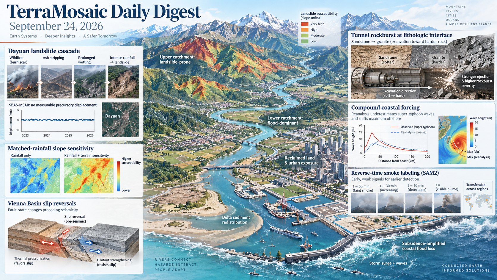
Landslide studies resolve how coupled disturbances and terrain sensitivity control failure. The fatal 2025 Dayuan landslide followed wildfire, ash stripping, prolonged wetting and a final intense rainfall burst; burned soil was one to two times more permeable, while SBAS-InSAR showed no measurable precursory displacement. In northern Sichuan, event-control matching within the same rainfall cell and recorded date shows that a process-aware slope-unit sensitivity index adds modest but persistent information beyond matched gridded rainfall. A Langat Catchment assessment integrates flood and landslide susceptibility at 10 m resolution, separating lower-catchment flood dominance from upstream landslide concentration.
Earthquake and geotechnical studies connect evolving fault state to design reliability. Fault-slip reversals preceded the 2021 Vienna Basin intraplate earthquake series, while laboratory ruptures quantify competition between thermal pressurization and dilatant strengthening. Reliability calibration for Canadian liquefaction design factors restores a consistent annual triggering probability across site conditions. Experiments on tunnels crossing sandstone-granite interfaces show that excavation from soft toward hard rock produces greater ejection velocity, kinetic energy and rockburst severity than the reverse direction; numerical studies extend the same process emphasis to injection-triggered seismicity and cyclic stress paths.
Coastal and hydrometeorological work exposes compound forcing that standard products miss. In reclaimed coastal land, subsidence offsets part of the protection gained from new defences and contributes to a projected loss near US509 million under a 100-year event. Satellite retrievals show that ERA5 underestimates super-typhoon maximum wave height by up to 5.4 m and shifts its location outward by 13.8 km. River-mouth morphology, tides and discharge jointly condition flood hazard, while sediment availability and redistribution explain global salt-marsh trajectories better than relative sea-level rise alone.
Observation and learning systems target the earliest, sparsest and most transferable signals. Reverse-time SAM2 propagation labels faint smoke before it becomes visually obvious, enabling a detector to identify 111 of 144 wildfire ignition sequences at a mean seven minutes after ignition. Physics-informed cryosphere altimetry, Arctic InSAR synthesis, control-free differential photogrammetry, seismic-processing benchmarks and geographic reasoning benchmarks expand the measurement layer. Across these methods, uncertainty, sensor geometry and transfer across regions are increasingly evaluated alongside nominal accuracy.
Key Trends
The strongest studies link hazard prediction to the physical history that creates vulnerability: disturbance sequence, material state, terrain organization and observation geometry.
- Cascading disturbances are replacing single-trigger explanations: Wildfire, ash removal, seasonal wetting and intense rainfall combine in Dayuan, while subsidence, reclamation and sea-level rise jointly shape coastal flood losses.
- Terrain sensitivity is being separated from forcing: Matched-rainfall slope-unit comparisons, integrated catchment susceptibility and river-mouth morphodynamics distinguish where exposure becomes failure from the magnitude of the forcing alone.
- Fault state and material path dependence are becoming observable: Slip reversals, thermal pressurization, dilatancy, cyclic stress paths and excavation direction reveal how loading history controls earthquakes, liquefaction and rockburst.
- Early warning is moving toward weak-signal supervision: Reverse-time smoke labeling, radar nowcasting, deformation measurement and uncertainty-aware forecasting target subtle signals that precede clear visual or threshold exceedance.
- Hazard products are being audited against spatial bias: Typhoon-wave diagnostics, precipitation downscaling and Earth-observation embeddings test location, transfer and resolution errors rather than reporting aggregate accuracy alone.
Selected Papers
The 24 September selection is led by a wildfire-rainfall reconstruction of the fatal Dayuan landslide, fault-slip reversal before Vienna Basin seismicity, terrain-mediated slope-unit sensitivity under matched rainfall and integrated flood-landslide susceptibility in Malaysia. Companion studies address rockburst across lithological interfaces, subsidence-amplified coastal flooding, liquefaction reliability, tsunami evacuation, wildfire-smoke detection, typhoon-wave bias, salt-marsh vulnerability, Arctic InSAR and geophysical inversion.
1. Coupled effects of wildfire, rainfall, terrain, and lithology on the failure of the Dayuan landslide
Core Problem: The 2025 Dayuan failure requires explanation of how antecedent wildfire, prolonged wetting, terrain and lithology combined despite no measurable pre-failure InSAR displacement.
Key Innovation: Integrates SBAS-InSAR, field mapping, soil tests and rainfall records to reconstruct ash removal, increased burned-soil permeability, concave-slope infiltration and intense final rainfall as a coupled failure sequence.
2. Fault Slip Reversals Preceded the Intraplate 2021 Earthquake Series in the Vienna Basin (Central Europe)
Core Problem: The preparatory deformation of intraplate earthquake sequences is difficult to resolve where regional strain rates are low.
Key Innovation: Documents fault-slip reversals preceding the 2021 Vienna Basin earthquake series, providing direct evidence of evolving fault state before intraplate seismicity.
3. Terrain-mediated slope-unit sensitivity and mapped rainfall-induced landslide occurrence under matched gridded rainfall exposure
Core Problem: Nearby slope units experiencing comparable gridded rainfall can differ in mapped landslide occurrence beyond what thresholds or static susceptibility explain.
Key Innovation: Audits 5,889 records and matches events to controls by date and rainfall cell, finding a modest but persistent complementary association from a process-aware hydrological sensitivity index without claiming exact triggering probability.
4. Integrating flood and landslide susceptibility for multi-hazard assessment in the Langat Catchment, Malaysia
Core Problem: Flood and landslide susceptibility are usually mapped separately even where both affect the same tropical catchment.
Key Innovation: Integrates frequency-ratio flood and landslide surfaces at 10 m resolution for Malaysia's Langat Catchment; the combined map attains AUC 0.803 and distinguishes downstream flood from upstream landslide dominance.
5. Rockburst Mechanisms in Tunnels Crossing Lithological Interfaces: An Experimental Analysis of Excavation Direction Effects
Core Problem: Tunnel excavation across soft–hard lithological interfaces redistributes stress and energy differently with direction, but the resulting rockburst asymmetry is poorly constrained.
Key Innovation: True-triaxial unloading tests show more violent failure from sandstone toward granite, linking direction-dependent damage, ejection and energy channels to excavation planning.
6. Assessing coastal flooding risk in newly reclaimed areas under the influence of relative sea level rise and multiple drivers
Core Problem: Land reclamation changes exposure and defence while low elevation and subsidence amplify relative sea-level rise.
Key Innovation: Combines InSAR subsidence with LISFLOOD-FP scenarios for Longgang through 2100, estimating nearly US$509 million loss under a 100-year event and exposing the limits of reclamation-driven defence gains.
7. Calibrating design factors to assess liquefaction triggering potential for Canadian sites
Core Problem: Code-based use of a 2475-year peak-ground-acceleration level does not ensure a consistent 1/2475 annual liquefaction-triggering probability across Canadian sites.
Key Innovation: Uses probabilistic liquefaction hazard analysis to calibrate site-dependent design factors as functions of soil depth, VS30 and groundwater depth, restoring target reliability across site classes.
8. Reverse-Time SAM2 Mask Propagation for Scalable Labeling and Early Detection of Wildfire Smoke
Core Problem: Human labels are least reliable for the faint smoke that matters most to early camera-based warning.
Key Innovation: Propagates SAM2 masks backward from visible smoke to early frames, producing 170,573 labeled frames; RT-DETR-L detects 111 of 144 ignition sequences at a mean 7.0 minutes after ignition.
9. Evacuation and Return Behavior of Residents and Visitors during the 2025 Kamchatka Far-Field Tsunami in Japan
Core Problem: Title-level focus: identifies evacuation and return decisions by residents and visitors during the 2025 Kamchatka far-field tsunami in Japan.
Key Innovation: Title-signalled approach or contribution: The title reports a behavioral disaster-response study; public metadata did not expose methods or quantitative results. Methods, data and results could not be assessed because no reliable abstract was available.
10. Household-Level Assessment of Urban Fire Risk in Dhaka, Bangladesh
Core Problem: Title-level focus: identifies household-scale fire risk in Dhaka as the assessment target.
Key Innovation: Title-signalled approach or contribution: The title reports a household-level urban-risk study; public metadata did not expose methods or quantitative results. Methods, data and results could not be assessed because no reliable abstract was available.
11. 160 Years of Etna summit craters through a photogrammetry-based time machine
Core Problem: Title-level focus: identifies the need to reconstruct 160 years of summit-crater evolution at Etna.
Key Innovation: Title-signalled approach or contribution: The title reports a photogrammetry-based historical reconstruction; public metadata did not expose methods or quantitative results. Methods, data and results could not be assessed because no reliable abstract was available.
12. Landslide susceptibility assessment using machine learning and information value models
Core Problem: Title-level focus: identifies comparative landslide-susceptibility assessment with machine learning and information-value models.
Key Innovation: Title-signalled approach or contribution: The title reports a direct landslide mapping application; public metadata did not expose study area, validation or quantitative results. Methods, data and results could not be assessed because no reliable abstract was available.
13. Spatiotemporal evaluation of landslide activity across pre- and post-wildfire phases: a data-driven framework
Core Problem: Title-level focus: identifies how landslide activity changes across pre- and post-wildfire phases.
Key Innovation: Title-signalled approach or contribution: The title reports a data-driven spatiotemporal framework; public metadata did not expose datasets or quantitative results. Methods, data and results could not be assessed because no reliable abstract was available.
14. Deep learning with upstream-aware terrain representations and rainfall adapter for generalizable pluvial flood prediction
Core Problem: Title-level focus: identifies generalization across basins as a limitation for rainfall-driven urban flood prediction.
Key Innovation: Title-signalled approach or contribution: The title reports upstream-aware terrain representations and a rainfall adapter; public metadata did not expose validation or quantitative results. Methods, data and results could not be assessed because no reliable abstract was available.
15. Numerical insights into impacts of constant and cycled injection rates on triggered seismicity in faulted reservoirs
Core Problem: Title-level focus: identifies how constant and cyclic injection rates alter triggered seismicity in faulted reservoirs.
Key Innovation: Title-signalled approach or contribution: The title reports numerical comparison of injection histories; public metadata did not expose methods or quantitative results. Methods, data and results could not be assessed because no reliable abstract was available.
16. River-mouth hydrodynamics and flood hazard potential: Interactions between river discharge, tidal forcing, and morphodynamic bar development
Core Problem: Title-level focus: identifies coupled discharge, tides and morphodynamic-bar evolution as controls on river-mouth flood potential.
Key Innovation: Title-signalled approach or contribution: The title reports a hydrodynamic and morphodynamic flood-hazard study; public metadata did not expose methods or quantitative results. Methods, data and results could not be assessed because no reliable abstract was available.
17. Teleseismic Rayleigh Wave Helmholtz Tomography in Northeastern Tibet Using Physics-Informed Neural Networks
Core Problem: In this study, we apply a physics‐informed neural network (PINN)‐based teleseismic Rayleigh wave Helmholtz tomography (pinnTHT) to investigate the crustal and upper mantle structure beneath the northeastern Tibetan Plateau.
Key Innovation: The method incorporates the Helmholtz equation directly into the loss function, allowing phase velocity, amplitude, and traveltime fields to be jointly constrained.
18. Evaluating Cross-region Generalization for Wavelet-Diffusion Precipitation Downscaling
Core Problem: Overall, these findings support future efforts to transfer downscaling models to regions with limited local training data and to generate globally consistent, high-resolution precipitation products.
Key Innovation: Building on the wavelet diffusion model (WDM) framework, this study evaluates cross-region and cross-event generalization.
19. SPBench: A Multi-Task Evaluation Benchmark for Exploration Seismic Processing
Core Problem: Exploration seismic processing underpins subsurface imaging and resource exploration, but learning-based methods remain difficult to compare across studies.
Key Innovation: We introduce the Seismic Processing Benchmark (SPBench), covering six tasks: random noise attenuation, trace interpolation, ground-roll suppression, multiple suppression, deblending, and first-arrival picking.
20. Recoverable Geographic Location Information in Earth-Observation Embeddings
Core Problem: Earth-observation (EO) foundation models provide reusable embeddings, yet downstream task accuracy does not reveal whether these representations encode geographic information, which may be beneficial for location-aware applications but potentially detrimental when representations invariant to geographic location are desired.
Key Innovation: We therefore evaluate the geographic coordinate robustness of Tessera v1, Tessera v1.1, and AlphaEarth by testing whether coordinates can be predicted from the embedding representations using 284 quality-verified European solar farms from 2024.
21. An Automated Georeferencing Technique for Multi-Temporal Stope Point Clouds for Downstream Geotechnical Analysis
Core Problem: However, in GNSS-denied underground environments, independently acquired stope point clouds are generated within local scanner reference frames and require registration and georeferencing before integration with mine reference data for downstream geotechnical analysis, monitoring, and mine planning.
Key Innovation: This study proposes the 3D Tag-based Automated Registration and Georeferencing Technique (3D-TARGeT), an automated framework using low-cost, generic, non-unique rectangular tags to establish spatial correspondence between stope point clouds and the mine reference coordinate system.
22. A higher-order gradient framework for multi-scale seismic wave propagation
Core Problem: Modeling frequency-dependent seismic wave propagation in porous media remains a major challenge because classical poroelastic theories generally require a large number of poorly constrained constitutive parameters.
Key Innovation: We investigate seismic wave propagation within a higher-order gradient constitutive framework as an effective dynamic homogenization model for poroelastic media.
23. GeoRefer-Bench: A Benchmark from Referring Pixels to Verifiable Geospatial Reasoning
Core Problem: Referring segmentation in overhead imagery is inherently relational: a query may ask for the buildings north of the road or the pond closest to a residential area, so the correct referent can contain one object, several objects, or none.
Key Innovation: We introduce GeoRefer-Bench, a benchmark for verifiable geospatial referring segmentation.
24. Spaceborne differential photogrammetry for control-free measurement of large-gradient deformation with structural immunity and a predictable accuracy envelope
Core Problem: However, standard pairwise workflows lack a pre-acquisition error budget and rely on extensive stable terrain.
Key Innovation: However, standard pairwise workflows lack a pre-acquisition error budget and rely on extensive stable terrain.
25. Competition between thermal pressurization and dilatant strengthening in laboratory ruptures
Core Problem: However, experimental constraints on their competition remain limited.
Key Innovation: However, experimental constraints on their competition remain limited.
26. WeatherDiagFlow: Evidence-Grounded Radar Nowcasting with Diagnostic Flow Refinement
Core Problem: Radar nowcasting is essential for short-term warning and emergency response, yet conventional systems mainly return future radar fields and provide limited support for operational communication and post-event verification.
Key Innovation: We formulate radar nowcasting as an evidence-grounded forecast--bulletin--audit task, in which a numerical forecaster produces both future radar fields and structured diagnostic evidence.
27. Efficient Continuous DEM Reconstruction under Limited Target-Resolution Supervision
Core Problem: To address this problem, SCOPE learns a continuous terrain representation from coarser-resolution pairs.
Key Innovation: Reconstructing finer terrain grids therefore requires both effective transfer beyond the supervised scale and control of dense-query computation.
28. Simulating SAR altimeter echoes from cryospheric surfaces with the Snow Microwave Radiative Transfer (SMRT) model version 1.7
Core Problem: Simulating SAR altimeter echoes from cryospheric surfaces with the Snow Microwave Radiative Transfer (SMRT) model version 1.7 Ghislain Picard, Justin Murfitt, Elena Zakharova, Pierre Zeiger, Laurent Arnaud, Jeremie Aublanc, Jack C.
Key Innovation: Landy, Michele Scagliola, and Claude Duguay Geosci.
29. Freeze-thaw processes influence shallow groundwater recharge sources and pathways in the Qinghai Lake Basin: insights from water isotopes
Core Problem: Freeze–thaw processes influence shallow groundwater recharge sources and pathways in the Qinghai Lake Basin: insights from water isotopes Wenhao Zhang, Xiaoyan Li, Yuanhong Deng, Guangrong Hu, and Fangzhong Shi Hydrol.
Key Innovation: Sci., 30, 6039–6055, https://doi.org/10.5194/hess-30-6039-2026, 2026 Groundwater plays a crucial role in maintaining baseflow in rivers and ensuring water supply, particularly in alpine regions where the freeze–thaw cycle exerts a strong influence.
30. Sediment dynamics drive global patterns of salt-marsh vulnerability
Core Problem: Salt marshes protect coastlines, support biodiversity, and store substantial blue carbon, yet their rates of gain and loss vary markedly around the world.
Key Innovation: Here, we combine satellite-derived global salt-marsh change with datasets describing hydro-sedimentary regimes, human pressure, and extreme events to identify the processes underlying this spatial heterogeneity.
31. Global-Scale Diagnoses of Tropical Cyclone Maximum Wave Heights from 5 Km GPM Retrievals and Their Implications for Reanalysis Bias
Core Problem: Tropical cyclone (TC) inner-core maximum wave height (MWH) measurements are virtually absent, forcing reliance on reanalyses such as ERA5.
Key Innovation: Using a GPM-retrieved dynamic MWH product on a 5 km pixel grid, 165 global TC–GPM overpass cases of tropical-storm intensity and above, drawn from 143 unique tropical cyclones (maximum sustained wind ≥17 m s−1; the weakest sampled storm peaked at 20 m s−1), are analyzed to evaluate ERA5 MWH in both magnitude and location.
32. Systematic Overestimation of Global Peak Runoff Synchronization in CMIP6 Models
Core Problem: As the hydrological cycle intensifies, flood synchronization appears to be expanding, yet predictive understanding beyond gauged basins remains limited.
Key Innovation: We show that exaggerated temporal dependence driven by overly concentrated and shifted peak timing is the primary source of this structural bias.
33. Global Characterization of Precipitation Peaks in the Seasonal Cycle
Core Problem: Abstract Precipitation seasonality is commonly described using wet and dry periods, but this framework can obscure multiple rainfall maxima within a rainy season.
Key Innovation: Here we introduce a global framework for identifying the number of precipitation peaks (NPP) during rainy periods from daily precipitation using optimal harmonic seasonal fits and reproducible peak‐selection criteria.
34. Decreasing Translation Speed of Rapid Expansion Tropical Cyclones Over the Western North Pacific
Core Problem: However, variations in translation speed of TCs undergoing rapid expansion (RE) over recent decades remain poorly understood.
Key Innovation: However, variations in translation speed of TCs undergoing rapid expansion (RE) over recent decades remain poorly understood.
35. A sea-spray momentum-flux partitioning framework for high-wind drag in typhoon wave hindcasting
Core Problem: Title-level focus: identifies the problem signaled by: A sea-spray momentum-flux partitioning framework for high-wind drag in typhoon wave hindcasting.
Key Innovation: Title-signalled approach or contribution: The title identifies the study direction, but the available public metadata do not expose methods, validation or quantitative results. Methods, data and results could not be assessed because no reliable abstract was available.
36. High-dimensional joint probability modeling of typhoon-induced wind-wave-current variables in the South China Sea
Core Problem: Title-level focus: identifies the need to model high-dimensional dependence among typhoon-driven wind, wave and current extremes.
Key Innovation: Title-signalled approach or contribution: The title reports joint probability modeling for the South China Sea; the acquired abstract described an unrelated Kuroshio review, so no methods or results are inferred. Methods, data and results could not be assessed because no reliable abstract was available.
37. Joint inversion of self-potential and active-source electrical data constrained by a Gaussian mixture model prior for detecting water-bearing anomalies in tunnels
Core Problem: Title-level focus: identifies water-bearing anomaly detection as an ill-constrained tunnel geophysics problem.
Key Innovation: Title-signalled approach or contribution: The title reports joint self-potential and active-source electrical inversion with a Gaussian-mixture prior; public metadata did not expose validation or quantitative results. Methods, data and results could not be assessed because no reliable abstract was available.
38. Interferometric SAR for monitoring the Arctic cryosphere: Progress, challenges, and perspectives
Core Problem: Title-level focus: identifies the problem signaled by: Interferometric SAR for monitoring the Arctic cryosphere: Progress, challenges, and perspectives.
Key Innovation: Title-signalled approach or contribution: The title identifies the study direction, but the available public metadata do not expose methods, validation or quantitative results. Methods, data and results could not be assessed because no reliable abstract was available.
39. Topology-preserving river vectorization via HydroSAM and differentiable graph optimization under coarse labels
Core Problem: Title-level focus: identifies the problem signaled by: Topology-preserving river vectorization via HydroSAM and differentiable graph optimization under coarse labels.
Key Innovation: Title-signalled approach or contribution: The title identifies the study direction, but the available public metadata do not expose methods, validation or quantitative results. Methods, data and results could not be assessed because no reliable abstract was available.
40. Constellation concepts for InSAR observations of Earth
Core Problem: Title-level focus: identifies the problem signaled by: Constellation concepts for InSAR observations of Earth.
Key Innovation: Title-signalled approach or contribution: The title identifies the study direction, but the available public metadata do not expose methods, validation or quantitative results. Methods, data and results could not be assessed because no reliable abstract was available.
41. Assessing snow cover and snowline altitude variability in the Upper Indus Basin using enhanced MODIS and ground-based climate observations
Core Problem: Title-level focus: identifies the problem signaled by: Assessing snow cover and snowline altitude variability in the Upper Indus Basin using enhanced MODIS and ground-based climate observations.
Key Innovation: Title-signalled approach or contribution: The title identifies the study direction, but the available public metadata do not expose methods, validation or quantitative results. Methods, data and results could not be assessed because no reliable abstract was available.
42. Surrogate-Assisted Multi-Domain PINN for Mechanism Identification of Buried Jointed Pipelines under Differential Settlement
Core Problem: Title-level focus: identifies the problem signaled by: Surrogate-Assisted Multi-Domain PINN for Mechanism Identification of Buried Jointed Pipelines under Differential Settlement.
Key Innovation: Title-signalled approach or contribution: The title identifies the study direction, but the available public metadata do not expose methods, validation or quantitative results. Methods, data and results could not be assessed because no reliable abstract was available.
43. Influence of alignment geometry on the global seismic response of tunnel systems
Core Problem: Title-level focus: identifies the problem signaled by: Influence of alignment geometry on the global seismic response of tunnel systems.
Key Innovation: Title-signalled approach or contribution: The title identifies the study direction, but the available public metadata do not expose methods, validation or quantitative results. Methods, data and results could not be assessed because no reliable abstract was available.
44. Groundwater response to ice loading as a potential contributor to glacier surge dynamics at Hispar Glacier, Karakoram
Core Problem: Title-level focus: identifies the problem signaled by: Groundwater response to ice loading as a potential contributor to glacier surge dynamics at Hispar Glacier, Karakoram.
Key Innovation: Title-signalled approach or contribution: The title identifies the study direction, but the available public metadata do not expose methods, validation or quantitative results. Methods, data and results could not be assessed because no reliable abstract was available.
45. Hydrologically constrained genetic programming for interpretable rainfall-runoff model discovery: A process-informed machine learning approach
Core Problem: Title-level focus: identifies the problem signaled by: Hydrologically constrained genetic programming for interpretable rainfall–runoff model discovery: A process–informed machine learning approach.
Key Innovation: Title-signalled approach or contribution: The title identifies the study direction, but the available public metadata do not expose methods, validation or quantitative results. Methods, data and results could not be assessed because no reliable abstract was available.
46. Climate-driven deformation of a clayey railway embankment: long-term field monitoring and numerical modelling
Core Problem: Title-level focus: identifies the problem signaled by: Climate-driven deformation of a clayey railway embankment: long-term field monitoring and numerical modelling.
Key Innovation: Title-signalled approach or contribution: The title identifies the study direction, but the available public metadata do not expose methods, validation or quantitative results. Methods, data and results could not be assessed because no reliable abstract was available.
47. A physics-constrained parametric neural operator for pressure-driven radial grout transport with Bingham yield, filtration and equivalent fracture opening
Core Problem: Title-level focus: identifies the problem signaled by: A physics-constrained parametric neural operator for pressure-driven radial grout transport with Bingham yield, filtration and equivalent fracture opening.
Key Innovation: Title-signalled approach or contribution: The title identifies the study direction, but the available public metadata do not expose methods, validation or quantitative results. Methods, data and results could not be assessed because no reliable abstract was available.
48. Shear behavior and particle breakage evolution of compacted weathered red-bed soft rock fill under saturated and unsaturated hydraulic conditions
Core Problem: Title-level focus: identifies the problem signaled by: Shear behavior and particle breakage evolution of compacted weathered red-bed soft rock fill under saturated and unsaturated hydraulic conditions.
Key Innovation: Title-signalled approach or contribution: The title identifies the study direction, but the available public metadata do not expose methods, validation or quantitative results. Methods, data and results could not be assessed because no reliable abstract was available.
49. Random field-based extended finite element analysis of crack propagation in rock: A highway tunnel case study
Core Problem: Title-level focus: identifies the problem signaled by: Random field-based extended finite element analysis of crack propagation in rock: A highway tunnel case study.
Key Innovation: Title-signalled approach or contribution: The title identifies the study direction, but the available public metadata do not expose methods, validation or quantitative results. Methods, data and results could not be assessed because no reliable abstract was available.
50. Mechanical properties and microstructural mechanisms of sodium alginate improved loess under freeze-thaw cycles
Core Problem: Title-level focus: identifies the problem signaled by: Mechanical properties and microstructural mechanisms of sodium alginate improved loess under freeze-thaw cycles.
Key Innovation: Title-signalled approach or contribution: The title identifies the study direction, but the available public metadata do not expose methods, validation or quantitative results. Methods, data and results could not be assessed because no reliable abstract was available.
51. Extreme response prediction and mooring control of a large outfitting ship under typhoon-induced wind-wave conditions using multidimensional environmental contours
Core Problem: Title-level focus: identifies the problem signaled by: Extreme response prediction and mooring control of a large outfitting ship under typhoon-induced wind-wave conditions using multidimensional environmental contours.
Key Innovation: Title-signalled approach or contribution: The title identifies the study direction, but the available public metadata do not expose methods, validation or quantitative results. Methods, data and results could not be assessed because no reliable abstract was available.
52. mSAR2Height: Physics-Guided Backscattering Reconstruction and ASK-UNet for Mountain Height Estimation from Single SAR Imagery
Core Problem: Title-level focus: identifies the problem signaled by: mSAR2Height: Physics-Guided Backscattering Reconstruction and ASK-UNet for Mountain Height Estimation from Single SAR Imagery.
Key Innovation: Title-signalled approach or contribution: The title identifies the study direction, but the available public metadata do not expose methods, validation or quantitative results. Methods, data and results could not be assessed because no reliable abstract was available.
53. Sparse UAV-GPR evidence for polythermal structure and subglacial channel in Laohugou Glacier No. 12, Tibetan Plateau
Core Problem: Title-level focus: identifies the problem signaled by: Sparse UAV-GPR evidence for polythermal structure and subglacial channel in Laohugou Glacier No. 12, Tibetan Plateau.
Key Innovation: Title-signalled approach or contribution: The title identifies the study direction, but the available public metadata do not expose methods, validation or quantitative results. Methods, data and results could not be assessed because no reliable abstract was available.
54. RainDSD: Joint Retrieval of Rain Rate and Drop-Size Distribution Parameters from GPM Microwave Imager
Core Problem: Title-level focus: identifies the problem signaled by: RainDSD: Joint Retrieval of Rain Rate and Drop-Size Distribution Parameters from GPM Microwave Imager.
Key Innovation: Title-signalled approach or contribution: The title identifies the study direction, but the available public metadata do not expose methods, validation or quantitative results. Methods, data and results could not be assessed because no reliable abstract was available.
55. Monitoring flooding-induced debris using SuperDove observations: Successes and challenges
Core Problem: Title-level focus: identifies the problem signaled by: Monitoring flooding-induced debris using SuperDove observations: Successes and challenges.
Key Innovation: Title-signalled approach or contribution: The title identifies the study direction, but the available public metadata do not expose methods, validation or quantitative results. Methods, data and results could not be assessed because no reliable abstract was available.
56. Time-Series Foundation Models That Understand Data Revisions
Core Problem: Historical observations are not always fixed: statistical agencies revise previously published values as new evidence arrives.
Key Innovation: We propose VINTAGE-TS, a revision-aware adaptation of a time-series foundation model that distinguishes observation time from information-availability time.
57. Token Clustering and Semantic Sequence Mamba for Hyperspectral Image Classification
Core Problem: Although hyperspectral images (HSIs) provide rich spectral-spatial information, accurate pixel-level classification remains challenging because of spectral-spatial heterogeneity and complex spatial structures.
Key Innovation: To address this limitation, we propose Token Clustering and Semantic Sequence Mamba (STMamba), which organizes sparse tokens into semantically coherent sequences for hyperspectral image classification with the following features.
58. SGA: Uncertainty Quantification for Multi-Step Forecasting in Time Series Foundation Models
Core Problem: However, existing TSFMs often suffer from significantly inherent uncertainty, which typically manifests as derived forecast branches emerging at each time step and spreading to subsequent steps; different forecast branches often exhibit varying forecasting performance, thereby undermining the credibility of TSFM forecasts.
Key Innovation: In this paper, we propose the Slicing-Graphing-Alignment (SGA) method to quantify the uncertainty of multi-step TSFM forecasts.
59. GeoNLI - A Natural Language Interpreter for Satellite Imagery
Core Problem: However, because these models are trained on heterogeneous data and vary across tasks, designing a unified model that performs well in captioning, visual question answering (VQA), and visual grounding remains challenging.
Key Innovation: For grounding, we propose multiple pipelines - RemoteSAM-SAM-v1, RemoteSAM-SAM-v2, and DiffuSAM - and ultimately adopt a majority-voting ensemble across EarthMind, RemoteSAM, SAM3, Falcon, RemoteSAM-SAM3-v1, RemoteSAM-SAM3-v2, and DiffuSAM predictions.
60. Passive LWIR Hyperspectral Ranging via Transmittance Extraction and Distance Alignment
Core Problem: Passive long-wave infrared (LWIR) hyperspectral ranging enables distance estimation in low-light and nighttime scenes by exploiting atmospheric absorption features in thermal radiance received through the atmosphere.Joint estimation of temperature, emissivity, and distance is computationally expensive.
Key Innovation: Reference-range joint inversion also uses a distance-invariant effective attenuation coefficient, which can bias range estimates.We introduce transmittance extraction and distance alignment (TEDA), which decouples range estimation from temperature--emissivity inversion.
61. Exploiting answer-invariant redundancies in satellite imagery for efficient VLM inference on edge
Core Problem: Onboard vision-language models could enable satellites to answer queries directly, but exhaustive tiled inference over high-resolution imagery is slow and energy-intensive.
Key Innovation: We present Rift, a two-stage system that performs query-conditioned tile pruning followed by elastic prefill to reduce token budget.
62. Graph-Based Semi-Supervised Hyperspectral Image Classification with Distance-Aware Spatial Measure
Core Problem: One of the open problems in graph-based semi-supervised HI classification is the need to consider relative spatial relationship between pixels in the image to improve the smoothness of the solution.
Key Innovation: One of them is the difficulty to obtain a large set of labeled samples to train the classifier.
63. Lightweight Probabilistic Downscaling from a Deterministic Base Model
Core Problem: Climate data downscaling is the task of increasing the spatial resolution of climate data, typically by generating fine-resolution regional climate data from coarse global model output.
Key Innovation: Recent machine learning (ML) work in the related task of weather forecasting has seen significant improvements due to newly devised training methods and architectural components, but these have not yet benefited downscaling.
64. A micromorphic constitutive framework for (non)linear softening modeling
Core Problem: Nonlinear shear softening in soils and rocks is commonly described using empirical modulus-reduction laws.
Key Innovation: We show that nonlinear shear softening can be described by a progressive reduction of the coupling between macroscopic and internal deformation.
65. HClimRep-Ocean: A Global Ocean Emulator on an Unstructured Mesh
Core Problem: Moreover, complex coastlines, narrow straits, and ice-covered seas make boundary representation a central challenge that atmospheric models do not face.
Key Innovation: We present HClimRep-Ocean, an ocean emulator that operates directly on the native unstructured mesh of FESOM2.
66. GeoDose-CP: Graph-Local Conformal Inference for Continuous-Treatment Earth Observation
Core Problem: Reliable intervention-oriented uncertainty quantification from Earth observation (EO) remains challenging when continuous treatment shifts, spatial dependence, limited support, and satellite-outcome uncertainty must be addressed simultaneously.
Key Innovation: This study presents GeoDose-CP, a support-aware conformal framework for localized stochastic potential outcomes under continuous or mixed continuous-atomic treatment.
67. Functional dynamic mode decomposition: Learning infinite-dimensional systems from data
Core Problem: In order to apply DMD to partial differential equations, the spatial domain is typically first discretized using finite difference or finite element techniques, thus implicitly rendering the problem finite-dimensional.
Key Innovation: We show that conventional DMD algorithms can be regarded as special cases of their functional DMD counterparts.
68. FMCW-LIO: A Doppler LiDAR-Inertial Odometry
Core Problem: From now on, however, the situation changes thanks to the novel Frequency Modulated Continuous Wave (FMCW) Doppler LiDARs.
Key Innovation: In the letter, we propose FMCW-LIO, a novel and robust LIO, leveraging intrinsic Doppler measurements from FMCW Doppler LiDARs.
69. Free-Init: Scan-Free, Motion-Free, and Correspondence-Free Initialization for Doppler LiDAR-Inertial Systems
Core Problem: Robust initialization is crucial for online systems.
Key Innovation: In the letter, a high-frequency and resilient initialization framework is designed for LiDAR-inertial systems, leveraging both inertial sensors and Doppler LiDAR.
70. M3GD: Multi-Modal Multi-View Geometric Diffusion for Camera-LiDAR Novel View Synthesis
Core Problem: Robotic novel view synthesis (NVS) must recover both visual appearance and metric 3D structure, yet most generative NVS methods rely only on images, overlooking LiDAR, a complementary sensor common on robotic platforms.
Key Innovation: We present M3GD, a Camera--LiDAR multimodal representation for generative NVS that composes independently pretrained 2D image and 3D point-cloud foundation models without separately pretraining a cross-modal translator.
71. Pi-Noise-Guided Student-Teacher Distillation Detector for Open-Vocabulary Aerial Object Detection
Core Problem: However, existing distillation methods lack a customized perception incentive mechanism, leading to a disconnect between perception with discrimination knowledge and poor inductive generalization.
Key Innovation: To this end, we propose a positive-incentive-noise-guided progressive prior accumulation student–teacher distillation network, which utilizes the structured perturbation of noise distribution to achieve tighter localization–classification synergy.
72. Subset-Driven Representation Learning for Hyperspectral Image Classification: Assessing Latent Space Quality Through Spectral-Spatial and Transformer-Based Models
Core Problem: Hyperspectral representation learning commonly relies on complete scenes, increasing computational cost even when only compact latent features are required for classification.
Key Innovation: Results show that comparable latent representations can often be learned using reduced training fractions, yielding competitive macroaveraged $F_{1}$ scores, especially when spectral–spatial or self-supervised transformer representations are used.
73. Global 30 m annual cropland extent dynamics (2000-2024): a harmonized baseline of structural evolution and regional disparities
Core Problem: Global 30 m annual cropland extent dynamics (2000–2024): a harmonized baseline of structural evolution and regional disparities Yuanhong Liao, Shuang Chen, Yuqi Bai, Jie Wang, and Peng Gong Earth Syst.
Key Innovation: Data, 18, 7071–7096, https://doi.org/10.5194/essd-18-7071-2026, 2026 To track changes in land used for crops, we used satellite observations to create annual global maps for 2000–2024 at a resolution of 30 m.
74. Integrating coupled surface-subsurface modelling and field measurements in a degraded fen: water-balance dynamics and a framework for evaluating rewetting measures
Core Problem: Integrating coupled surface–subsurface modelling and field measurements in a degraded fen: water-balance dynamics and a framework for evaluating rewetting measures Nariman Mahmoodi, Christoph Merz, Jürgen Pickert, and Ottfried Dietrich Hydrol.
Key Innovation: Sci., 30, 6019–6037, https://doi.org/10.5194/hess-30-6019-2026, 2026 This paper applies a coupled 3D surface–subsurface model to a degraded fen peatland using long-term field data on evapotranspiration, groundwater, vegetation, and ditch water levels.
75. Discovering how ice crystals grow using neural ODEs and symbolic regression
Core Problem: Depositional ice growth strongly influences the evolution and lifetime of ice-containing clouds on Earth and Mars, yet its physics remain uncertain because the earliest stages of ice-crystal growth cannot be directly observed and are sparsely sampled in laboratory settings.
Key Innovation: Here, we use physics-informed machine learning to learn the functional dependence of unknown physics in the depositional ice growth model from limited observations.
76. Interpretable prediction of uniaxial compressive strength for diverse rock materials: a stacking ensemble approach
Core Problem: Uniaxial compressive strength (UCS) is critical for geotechnical design, yet conventional testing is costly and empirical formulas fail to adequately capture inherent nonlinearities.
Key Innovation: This study proposes an interpretable predictive framework that combines a two-stage heterogeneous stacking ensemble with SHapley Additive exPlanations (SHAP) for UCS estimation.
77. Leakage-aware full-section evaluation and label-efficient semi-supervised seismic facies segmentation for subsurface geological modeling
Core Problem: IntroductionSeismic facies segmentation is a fundamental step in subsurface geological modeling, but reported accuracies are difficult to compare because random splits of overlapping patches can leak spatial information across training and test sets.MethodsWe developed a leakage-aware evaluation protocol that uses complete inline or crossline sections, spatially contiguous splits, buffer gaps, and independent test cubes.
Key Innovation: Under a unified training recipe, we re-evaluated 11 representative convolutional neural network and Transformer architectures on the Netherlands F3 dataset.
78. Temporal and Spatial Associations of L-Band Fully Polarimetric SAR Metrics with Soil Moisture over a Wet Volcanic Ash Soil Field
Core Problem: The IIEM comparison supports a dielectric surface-scattering contribution to VV, whereas the weak VWC association and large model discrepancy of HV indicate limited usefulness for temporal moisture monitoring at this site.
Key Innovation: We compared 21 fully polarimetric ALOS-2/PALSAR-2 acquisitions with time-domain reflectometry (TDR) observations at 12 locations in a short-grass volcanic ash soil field.
79. Unified Multi-Application Segmentation of High-Resolution Satellite Images Through Consensus-Based Probabilistic Fusion
Core Problem: Deep-learning-based land cover segmentation models for high-resolution aerial images often suffer from inconsistent performance on unseen data due to limited spatial and temporal dataset ranges alongside inherent labeling inconsistencies.
Key Innovation: Existing solutions, such as foundation models and unsupervised domain adaptation, offer indirect improvements but require considerable post-processing or transfer learning.
80. Interpreting AlphaEarth Foundation Model Embeddings for Soil Organic Carbon Estimation Across European Agricultural Landscapes
Core Problem: However, conventional optical approaches are often constrained by the limited availability of bare-soil observations, particularly in cropping systems affected by vegetation cover, residues and conservation practices.
Key Innovation: However, conventional optical approaches are often constrained by the limited availability of bare-soil observations, particularly in cropping systems affected by vegetation cover, residues and conservation practices.
81. From Training to Practice: Evaluating Community Learning for Indigenous Knowledge Integration in Digital Environmental Monitoring
Core Problem: For millennia Indigenous communities worldwide have maintained diverse knowledge systems informed through careful observation of dynamics of environmental changes.
Key Innovation: We develop indicators for assessing responsible community engagement in research practice and identify patterns in levels of Indigenous community engagement.
82. Limited local classification performance but promising spatial transferability of AlphaEarth Foundations for crop mapping across thermal gradients
Core Problem: In cross-region transfer, however, AEF accuracy declined more slowly as the thermal difference between training and test regions increased.
Key Innovation: Although AEF performs strongly across land-use and land-cover mapping tasks, its suitability for crop-type mapping remains underexplored.
83. Spatiotemporal dynamics and driving mechanisms of suspended sediment concentration in the Yellow River revealed by machine learning and multi-source remote sensing
Core Problem: Accurate water extraction and quantitative estimation of water quality are two key and challenging issues for remote sensing of water environment.
Key Innovation: Recent advances in remote sensing big data, cloud computing, and machine learning have promoted these two fields into a new era.
84. Simulation of Coastal El Niño Events in CMIP6 Models and Its Relationship to Mean-State and ENSO Biases
Core Problem: Abstract Coastal El Niño (COA) events follow two evolution pathways, remaining in the far eastern Pacific or expanding into basin‐wide El Niño events.
Key Innovation: Analyzing 55 CMIP6 models, we show that the two pathways are associated with distinct central and eastern Pacific ocean‐atmosphere conditions, and the simulated frequency of each type is linked to tropical Pacific mean‐state biases (zonal for standalone, meridional for spreading) while inversely related to ENSO simulation skill.
85. Cyclic Response of Sand under Parabolic- or Butterfly-Shaped In Situ Stress Paths
Core Problem: Abstract Cyclic tests are presented to investigate the behavior of sands under complex in situ loading paths.
Key Innovation: The parabolic- and butterfly-shaped stress path trajectories considered may result from simultaneous compression and shear wave loading during earthquakes.
86. DescribeEarth: Detailed localized captioning for remote sensing images
Core Problem: Title-level focus: identifies the need for detailed, spatially localized descriptions of remote-sensing imagery.
Key Innovation: Title-signalled approach or contribution: The title reports a localized captioning system; public metadata did not expose datasets or quantitative validation. Methods, data and results could not be assessed because no reliable abstract was available.
87. Active CO₂ lidar extends satellite monitoring of urban fossil-fuel CO₂ emissions to high-aerosol cities
Core Problem: Title-level focus: identifies aerosol interference as a limitation for satellite monitoring of urban fossil-fuel CO₂.
Key Innovation: Title-signalled approach or contribution: The title reports active-CO₂-lidar extension to high-aerosol cities; public metadata did not expose methods or quantitative results. Methods, data and results could not be assessed because no reliable abstract was available.
88. Challenges and crucial construction aspects for an artificial island and underwater interchange tunnels adjacent to operating expressway bridges: A case study of Shenzhen-Zhongshan Link, China
Core Problem: Title-level focus: identifies construction challenges where artificial-island and underwater interchange tunnels adjoin operating bridges.
Key Innovation: Title-signalled approach or contribution: The title reports a Shenzhen–Zhongshan Link case study; public metadata did not expose methods or quantitative results. Methods, data and results could not be assessed because no reliable abstract was available.
89. Lithology-dependent energy partitioning and multi-hole fragmentation control in blasting of hard and soft rocks
Core Problem: Title-level focus: identifies the problem signaled by: Lithology-dependent energy partitioning and multi-hole fragmentation control in blasting of hard and soft rocks.
Key Innovation: Title-signalled approach or contribution: The title identifies the study direction, but the available public metadata do not expose methods, validation or quantitative results. Methods, data and results could not be assessed because no reliable abstract was available.
90. Investigation on real-time permeability evolution of granite under subcritical and supercritical water conditions
Core Problem: Title-level focus: identifies real-time permeability change under subcritical and supercritical water conditions.
Key Innovation: Title-signalled approach or contribution: The title reports an experimental granite study; public metadata did not expose methods or quantitative results. Methods, data and results could not be assessed because no reliable abstract was available.
91. Damage accumulation in water-saturated sandstone under multi-level cyclic disturbance: Insights from fatigue mechanical behavior and constitutive modeling
Core Problem: Title-level focus: identifies the problem signaled by: Damage accumulation in water-saturated sandstone under multi-level cyclic disturbance: Insights from fatigue mechanical behavior and constitutive modeling.
Key Innovation: Title-signalled approach or contribution: The title identifies the study direction, but the available public metadata do not expose methods, validation or quantitative results. Methods, data and results could not be assessed because no reliable abstract was available.
92. Modeling anisotropic rocks by 3D reconstruction method and LayerDFN model: A case study in the Yuan’an underground research cavern
Core Problem: Title-level focus: identifies representation of anisotropic rock structure as a modeling bottleneck.
Key Innovation: Title-signalled approach or contribution: The title reports 3D reconstruction and LayerDFN modeling in the Yuan'an underground research cavern; public metadata did not expose validation or quantitative results. Methods, data and results could not be assessed because no reliable abstract was available.
93. Evaluating spectral unmixing techniques using imaging spectroscopy data for retrieval of green, non-photosynthetic vegetation, and soil fractional cover
Core Problem: Title-level focus: identifies the problem signaled by: Evaluating spectral unmixing techniques using imaging spectroscopy data for retrieval of green, non-photosynthetic vegetation, and soil fractional cover.
Key Innovation: Title-signalled approach or contribution: The title identifies the study direction, but the available public metadata do not expose methods, validation or quantitative results. Methods, data and results could not be assessed because no reliable abstract was available.
94. SPN-Geo: A Stream-Oriented Physics-Neural Framework for On-Board Geolocation of Fengyun Meteorological Satellites
Core Problem: Title-level focus: identifies the problem signaled by: SPN-Geo: A Stream-Oriented Physics-Neural Framework for On-Board Geolocation of Fengyun Meteorological Satellites.
Key Innovation: Title-signalled approach or contribution: The title identifies the study direction, but the available public metadata do not expose methods, validation or quantitative results. Methods, data and results could not be assessed because no reliable abstract was available.
95. Impact of CO₂-induced dissolution and salt precipitation on net changes in elastic and viscoplastic properties of chalk under near-wellbore conditions
Core Problem: Title-level focus: identifies the problem signaled by: Impact of CO2-induced dissolution and salt precipitation on net changes in elastic and viscoplastic properties of chalk under near-wellbore conditions.
Key Innovation: Title-signalled approach or contribution: The title identifies the study direction, but the available public metadata do not expose methods, validation or quantitative results. Methods, data and results could not be assessed because no reliable abstract was available.
96. Shear behavior and progressive failure of grout-rock interfaces in soft-hard interbedded rock: Role of soft-layer proportion
Core Problem: Title-level focus: identifies the problem signaled by: Shear behavior and progressive failure of grout–rock interfaces in soft–hard interbedded rock: Role of soft-layer proportion.
Key Innovation: Title-signalled approach or contribution: The title identifies the study direction, but the available public metadata do not expose methods, validation or quantitative results. Methods, data and results could not be assessed because no reliable abstract was available.
97. Root water uptake estimation and associated ecohydrological functions based on distributed moisture storage dynamics in soil-weathered bedrock profiles
Core Problem: Title-level focus: identifies the problem signaled by: Root water uptake estimation and associated ecohydrological functions based on distributed moisture storage dynamics in soil-weathered bedrock profiles.
Key Innovation: Title-signalled approach or contribution: The title identifies the study direction, but the available public metadata do not expose methods, validation or quantitative results. Methods, data and results could not be assessed because no reliable abstract was available.
98. Fourier spectral heuristic indices for streamflow complexity and predictability
Core Problem: Title-level focus: identifies the problem signaled by: Fourier spectral heuristic indices for streamflow complexity and predictability.
Key Innovation: Title-signalled approach or contribution: The title identifies the study direction, but the available public metadata do not expose methods, validation or quantitative results. Methods, data and results could not be assessed because no reliable abstract was available.
99. Conditional normalizing flows: a generative framework for probabilistic streamflow forecasting
Core Problem: Title-level focus: identifies the problem signaled by: Conditional normalizing flows: a generative framework for probabilistic streamflow forecasting.
Key Innovation: Title-signalled approach or contribution: The title identifies the study direction, but the available public metadata do not expose methods, validation or quantitative results. Methods, data and results could not be assessed because no reliable abstract was available.
100. Unearthing dominant controls of precipitation - streamflow interaction using information theory and explainable AI in large-sample hydrology
Core Problem: Title-level focus: identifies the problem signaled by: Unearthing dominant controls of precipitation – streamflow interaction using information theory and explainable AI in large-sample hydrology.
Key Innovation: Title-signalled approach or contribution: The title identifies the study direction, but the available public metadata do not expose methods, validation or quantitative results. Methods, data and results could not be assessed because no reliable abstract was available.
101. Dynamic response of a fractional layered viscoelastic foundation with an embedded circular tunnel subjected to underground moving loads
Core Problem: Title-level focus: identifies the problem signaled by: Dynamic response of a fractional layered viscoelastic foundation with an embedded circular tunnel subjected to underground moving loads.
Key Innovation: Title-signalled approach or contribution: The title identifies the study direction, but the available public metadata do not expose methods, validation or quantitative results. Methods, data and results could not be assessed because no reliable abstract was available.
102. Modelling of large-span composite soil-steel bridges from construction to collapse: A critical evaluation of numerical schemes and assumptions
Core Problem: Title-level focus: identifies the problem signaled by: Modelling of large-span composite soil-steel bridges from construction to collapse: A critical evaluation of numerical schemes and assumptions.
Key Innovation: Title-signalled approach or contribution: The title identifies the study direction, but the available public metadata do not expose methods, validation or quantitative results. Methods, data and results could not be assessed because no reliable abstract was available.
103. Full-depth sensing and automated signal processing for monitoring in-service asphalt pavement temperature and mechanical responses
Core Problem: Title-level focus: identifies the problem signaled by: Full-depth sensing and automated signal processing for monitoring in-service asphalt pavement temperature and mechanical responses.
Key Innovation: Title-signalled approach or contribution: The title identifies the study direction, but the available public metadata do not expose methods, validation or quantitative results. Methods, data and results could not be assessed because no reliable abstract was available.
104. Adaptive residual-gradient sampling PINNs for unsteady wake reconstruction around offshore cylinder arrays
Core Problem: Title-level focus: identifies the problem signaled by: Adaptive residual-gradient sampling PINNs for unsteady wake reconstruction around offshore cylinder arrays.
Key Innovation: Title-signalled approach or contribution: The title identifies the study direction, but the available public metadata do not expose methods, validation or quantitative results. Methods, data and results could not be assessed because no reliable abstract was available.
105. A 1D macro-element model for suction caissons under inclined loading via scaling from Hardening-Soil relation
Core Problem: Title-level focus: identifies the problem signaled by: A 1D macro-element model for suction caissons under inclined loading via scaling from Hardening-Soil relation.
Key Innovation: Title-signalled approach or contribution: The title identifies the study direction, but the available public metadata do not expose methods, validation or quantitative results. Methods, data and results could not be assessed because no reliable abstract was available.
106. Offshore wind power forecasting based on phase-space guided representation and regime-adaptive differential attention mechanism
Core Problem: Title-level focus: identifies the problem signaled by: Offshore wind power forecasting based on phase-space guided representation and regime-adaptive differential attention mechanism.
Key Innovation: Title-signalled approach or contribution: The title identifies the study direction, but the available public metadata do not expose methods, validation or quantitative results. Methods, data and results could not be assessed because no reliable abstract was available.
107. Spatiotemporal Dynamics and Future Projections of Qinghai Lake Area Changes
Core Problem: Title-level focus: identifies the problem signaled by: Spatiotemporal Dynamics and Future Projections of Qinghai Lake Area Changes.
Key Innovation: Title-signalled approach or contribution: The title identifies the study direction, but the available public metadata do not expose methods, validation or quantitative results. Methods, data and results could not be assessed because no reliable abstract was available.
108. SatOrtho: Satellite-Map-Prior-Assisted Real-Time Orthophoto Generation
Core Problem: Title-level focus: identifies the problem signaled by: SatOrtho: Satellite-Map-Prior-Assisted Real-Time Orthophoto Generation.
Key Innovation: Title-signalled approach or contribution: The title identifies the study direction, but the available public metadata do not expose methods, validation or quantitative results. Methods, data and results could not be assessed because no reliable abstract was available.
109. A Novel Physics-Based Empirical Line Approach for Reflectance Calibration of UAV Multispectral Imagery
Core Problem: Title-level focus: identifies the problem signaled by: A Novel Physics-Based Empirical Line Approach for Reflectance Calibration of UAV Multispectral Imagery.
Key Innovation: Title-signalled approach or contribution: The title identifies the study direction, but the available public metadata do not expose methods, validation or quantitative results. Methods, data and results could not be assessed because no reliable abstract was available.
110. A comparative understanding of variable SPT energy measurement in practice
Core Problem: Title-level focus: identifies the problem signaled by: A comparative understanding of variable SPT energy measurement in practice.
Key Innovation: Title-signalled approach or contribution: The title identifies the study direction, but the available public metadata do not expose methods, validation or quantitative results. Methods, data and results could not be assessed because no reliable abstract was available.
111. FounRef: Robust, Structure-Preserving, and Fast Metric Refinement of Frozen Monocular Foundation Priors with Sparse Anchors
Core Problem: Monocular foundation models provide rich, transferable geometric priors but lack reliable metric scale, while depth-completion networks recover metric depth at the cost of geometric fidelity, cross-domain robustness, or speed.
Key Innovation: We present FounRef, a training-free method that aligns a frozen monocular foundation prior with sparse metric anchors to produce dense metric depth.
112. Topological dynamics within the dissipative structure of granular materials at the critical state
Core Problem: Canadian Geotechnical Journal, Volume 63, Issue , Page 1-18, January 2026.
Key Innovation: Granular materials subjected to shear loading may reach a critical state where stress and volume remain constant while shear strain continues to develop.
113. Strength improvement in biopolymer-treated clay: decoupling the role of densification and bonding
Core Problem: Canadian Geotechnical Journal, Volume 63, Issue , Page 1-21, January 2026.
Key Innovation: This study presents a controlled experimental framework to isolate intrinsic biopolymer bonding from strength gains induced by densification (void ratio reduction) in stabilized high-plasticity clay.
114. A Probabilistic multi-objective optimization framework for offshore wind turbine jacket substructure under aero-hydrodynamic loading using surrogate models
Core Problem: With such wide-ranging studies available in the public domain, there is a need to carry out an extensive yet critical literature review on the recent advancements in offshore wind turbine technology.
Key Innovation: Researchers around the globe have been reporting significant scientific advancements in offshore wind turbines technology, addressing key issues, such as aerodynamic characteristics of turbine blades, dynamic response of the turbine, structural integrity of the turbine foundation, design of the mooring cables, ground scouring and cost modelling for commercial viability.
115. Study on the Evolution and Driving Factors of Coastal Wetland Ecological Environment Quality Based on the Improved Ecological Index CWESI
Core Problem: To address ecological degradation in estuarine coastal wetlands caused by the combined pressures of land–sea interactions and anthropogenic activities, we developed an improved Coastal Wetland Ecological Status Index (CWESI).
Key Innovation: These results show that wetland ecological quality is regulated by the synergistic interactions among multiple environmental factors.
116. A Joint Spatial-Frequency Network with a Multi-Dimensional Loss Function for Remote Sensing Image Super-Resolution
Core Problem: Remote sensing image super-resolution (SR) aims to recover high-resolution images from low-resolution observations, but existing deep networks often emphasize spatial-domain modeling and pixel-wise optimization, which may limit their ability to restore high-frequency textures and preserve perceptual structures.
Key Innovation: To address these limitations, this study proposes a joint spatial–frequency domain SR reconstruction network (JSF-SRNet) and a joint loss function with pixel-level, multi-scale, and global constraints (JLF-PMG).
117. A Teacher-Student Point Cloud Segmentation Framework for Challenging Features
Core Problem: Existing point cloud semantic segmentation models tend to favor classes with abundant points and salient structures, while sparse, small-scale, and confusable targets remain insufficiently represented.
Key Innovation: To address this issue, we propose an offline teacher–student point cloud segmentation framework for challenging features.
118. Spatiotemporal patterns of ecological condition under water-salt stress in the yellow river delta: an improved remote sensing ecological index approach
Core Problem: However, in coastal wetlands, the performance of the WET index is often undermined due to high soil salinity caused by seawater intrusion.
Key Innovation: Results show higher WSS (> 0.7) in tide-influenced coastal areas and lower WSS (< 0.4) near inland channels.
119. Unsaturated Triaxial Behaviour of Nilgiris Lateritic Soil under Constant Suction and Water Content Conditions
Core Problem: A comprehensive experimental program involving constant-suction (CS) and constant-water-content (CW) unsaturated triaxial tests was conducted on a tropical residual soil from a rainfall-induced landslide site at Madithorai in the Nilgiris, Western Ghats, India.
Key Innovation: The study aimed to characterize the shear strength behaviour of lateritic soil under controlled suction and water content conditions.
120. Axial Compression Behavior of Wavy Micropiles: Experimental and Numerical Investigation
Core Problem: This paper assesses the prospective enhancement in the axial compressive performance of advanced wavy micropiles in sands at diverse relative densities via experimental testing and three-dimensional numerical simulations.
Key Innovation: In this study, a series of small-scale wavy micropile models with assorted waveforms was conducted in the laboratory.
121. A vision-based multi-point vibration monitoring method for large wind turbine blades under complex environments
Core Problem: Title-level focus: identifies the problem signaled by: A vision-based multi-point vibration monitoring method for large wind turbine blades under complex environments.
Key Innovation: Title-signalled approach or contribution: The title identifies the study direction, but the available public metadata do not expose methods, validation or quantitative results. Methods, data and results could not be assessed because no reliable abstract was available.
122. Organic-rich strata in the basins of Kazakhstan: New perspectives for CO₂ geological storage and H2 generation
Core Problem: Title-level focus: identifies the problem signaled by: Organic-rich strata in the basins of Kazakhstan: New perspectives for CO 2 geological storage and H 2 generation.
Key Innovation: Title-signalled approach or contribution: The title identifies the study direction, but the available public metadata do not expose methods, validation or quantitative results. Methods, data and results could not be assessed because no reliable abstract was available.
123. Evaluation and modification of analytical models for the peak uplift soil resistance of buried pipelines in unsaturated soils
Core Problem: Title-level focus: identifies uncertainty in analytical peak uplift-resistance models for pipelines in unsaturated soil.
Key Innovation: Title-signalled approach or contribution: The title reports evaluation and modification of analytical models; public metadata did not expose validation or quantitative results. Methods, data and results could not be assessed because no reliable abstract was available.
124. MSSAM: Multi-Scale Spatial-Aware Mamba for Multimodal Remote Sensing Image Classification
Core Problem: Title-level focus: identifies the problem signaled by: MSSAM: Multi-Scale Spatial-Aware Mamba for Multimodal Remote Sensing Image Classification.
Key Innovation: Title-signalled approach or contribution: The title identifies the study direction, but the available public metadata do not expose methods, validation or quantitative results. Methods, data and results could not be assessed because no reliable abstract was available.
125. Patch-to-Channel Adaptive Graph Upsampling for Pan-sharpening
Core Problem: Title-level focus: identifies the problem signaled by: Patch-to-Channel Adaptive Graph Upsampling for Pan-sharpening.
Key Innovation: Title-signalled approach or contribution: The title identifies the study direction, but the available public metadata do not expose methods, validation or quantitative results. Methods, data and results could not be assessed because no reliable abstract was available.
126. Graph-Guided Spectral Differentiation for Unsupervised Hyperspectral Band Selection
Core Problem: Title-level focus: identifies the problem signaled by: Graph-Guided Spectral Differentiation for Unsupervised Hyperspectral Band Selection.
Key Innovation: Title-signalled approach or contribution: The title identifies the study direction, but the available public metadata do not expose methods, validation or quantitative results. Methods, data and results could not be assessed because no reliable abstract was available.