Community-Curated · Open-Access · Global
Connect the Pieces of Global Landslide Research
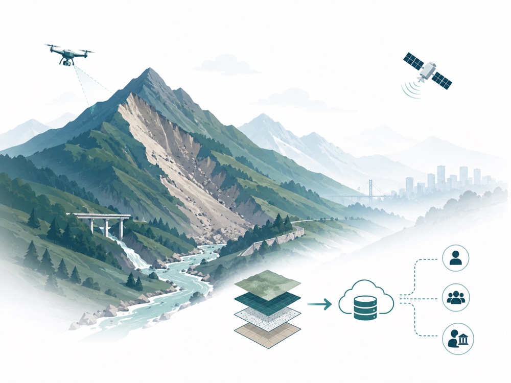
Existing landslide data is fragmented. We are building a community-curated, open-access platform to aggregate global landslide data, enabling reliable and scalable geohazard intelligence for more resilient communities.
Updates
Latest Posts
Stay up to date with the latest TerraMosaic updates
12
July 2026
TerraMosaic Digest
16
June 2026
AI Insights
Xin - AI Agent Field Notes (July 4, 2026 updated)
16
June 2026
Conference & Workshop
AGU 2026 Session NH052: Toward Reliable and Scalable Geohazard Intelligence (coming soon)
04
July 2026
Video
It's Happening - A Super El Niño Is Coming - Dr Ben Miles
17
Mar 2026
AI Insights
MIDAS AI DIGEST: Meet the AI Sandbox @ AIIR + Showcases | TimeCopilot | NIH Data Catalog | More
08
Apr 2026
Opportunities
USGS Cooperative Landslide Hazard Mapping and Assessment Program Announcement for Fiscal Year 2026
21
Mar 2026
Conference & Workshop
5th Geodata and AI Frontier Forum
13
Mar 2026
Publication
Review Article: The Critical Role of Soil Moisture in Compound Hazards
22
Feb 2026
AI Insights
THE 2028 GLOBAL INTELLIGENCE CRISIS: A Thought Exercise in Financial History, from the Future
10
Feb 2026
Publication
Top-Journal Foundation Models in Earth & Environment (Rolling Updates)
09
Feb 2026
Publication
Top-Journal Landslide-Related Papers (Rolling Updates)
08
Feb 2026
Opportunities
2026 Landslide & Geohazard Grant Opportunities (Rolling Updates)
01
May 2026
Opportunities
Call for Papers (Special Issue) — AI-Empowered Reliability, Resilience and Sustainability Analysis for Geotechnical and Underground Engineering
27
Feb 2026
Opportunities
NASA ROSES-2025 A.6: LACCE Science Team Call Open (NOI Feb 27, Proposals Apr 14)
26
Jan 2026
Opportunities
NASA's ARSET Program — Free Remote Sensing Training
04
Feb 2026
Opportunities
CLaSH Small Grant Program 2025–2026
30
Jan 2026
AI Insights
MIDAS AI DIGEST: AI Sandbox Showcases | TranslateGemma | TerraMosaic | Clinical Trail Randomization Tool | More
01
Jan 2026
Conference
Key Conferences & Workshops in Geohazards and AI/ML (2025–2026)
18
Dec 2025
Conference
NH33B - Toward Reliable and Scalable Geohazard Intelligence: From Multiscale Sensing to Open Data Foundations II Oral
21
Nov 2025
AI Insights
Orchestra: AI-Native Research, From Idea to Publication
Explore
Explore Our Sections
Five ways into the platform — each piece adds to the bigger picture.
News & Blogs
Conferences, workshops, and research announcements — plus the TerraMosaic Daily Digest.
Read the latestDatasets
Browse and download comprehensive landslide datasets from around the world.
Explore datasetsPaper Sharing
Curated research across landslide and geohazard science.
Browse papersTools & Code
Open-source tools, code libraries, and foundational data.
Get the toolsPeople
The team and contributors behind the platform, across institutions.
Meet the community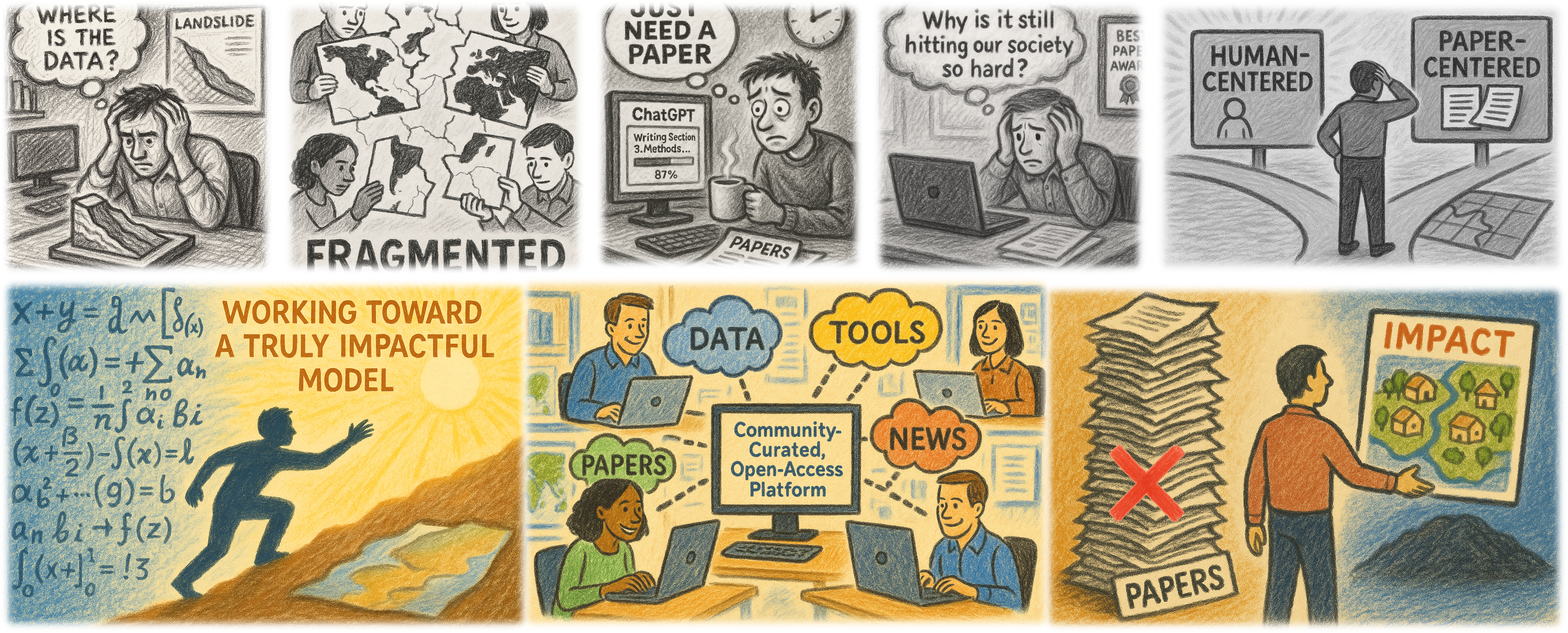
Our Mission
A central hub for AI-ready landslide data
Building a community-curated, open-access platform of global landslide datasets to support reliable and scalable AI models.
Recent advances in machine learning and deep learning have significantly advanced landslide-related applications, including detection, early warning, and susceptibility mapping. Generative AI further offers new opportunities to accelerate landslide research through rapid prototyping and iteration of ML/DL workflows.
However, most existing models are trained on datasets specific to certain regions or landslide types, resulting in poor or untested generalization across different geographic and environmental settings. Open-access landslide datasets remain fragmented across individual publications, institutional repositories, and project-specific websites — researchers spend substantial time locating, retrieving, and preparing data, and progress remains constrained by the lack of high-quality, high-volume, standardized, and accessible datasets.
To address this gap, TerraMosaic aggregates global landslide inventories and related geospatial data, with detailed metadata for every dataset — inventory type, record count, spatial resolution, geographic coverage, input features, ML/DL models used, evaluation settings, and whether cross-regional generalization was tested. Users can search, filter, and download datasets through an interactive map-based interface, and contribute new data via an easy-to-use upload flow. It serves as a central hub supporting the development and benchmarking of reliable, scalable, and generalizable AI models for both fundamental research and real-world applications.
Partners
Built together, across institutions
Labs, centers, and programs collaborating on open geohazard data.
Hover to pause and explore.