
TerraMosaic Daily Digest: September 25, 2026
Daily Summary
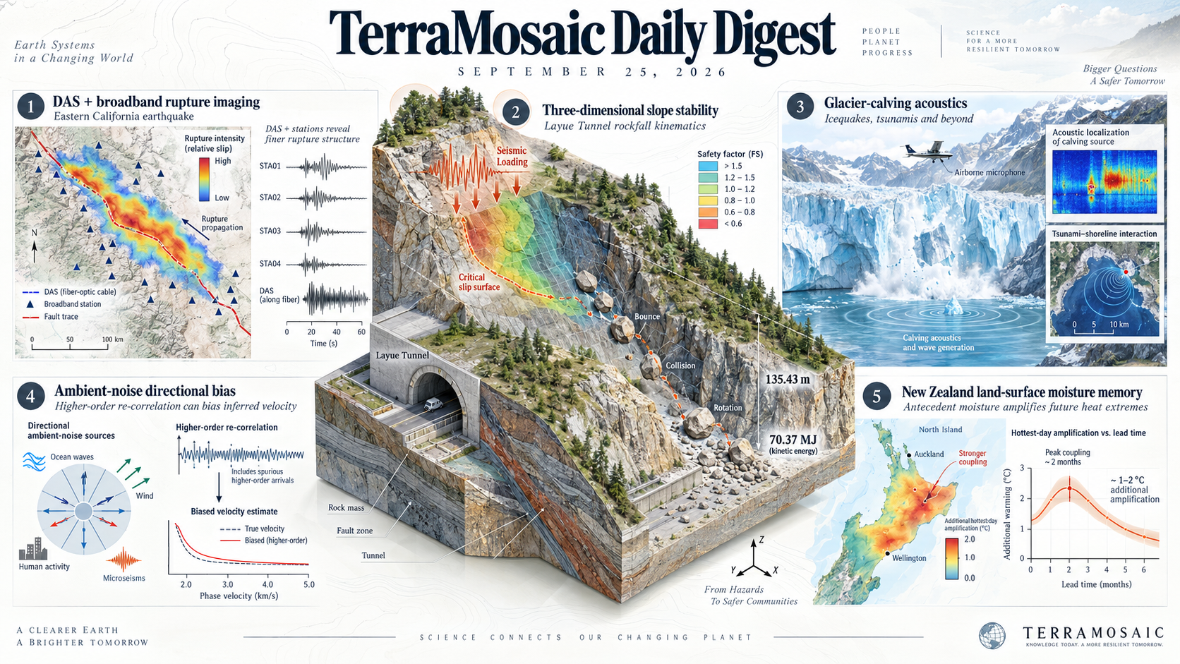
Slope-hazard studies connect three-dimensional mechanics to site-scale assessment. A rapid safety-factor formulation for seismically loaded slopes is derived from numerical critical-state configurations and checked against engineering examples. At the Layue Tunnel entrance, discontinuous deformation analysis is first tested against block experiments and then applied to UAV-derived terrain. The modeled boulder travels 135.43 m and reaches 70.37 MJ of kinetic energy, illustrating the importance of collision, bouncing and rotation when identifying exposed construction areas.
Acoustic measurements recover events at contrasting scales. Distributed acoustic sensing combined with broadband stations resolves finer rupture structure in a moderate Eastern California earthquake. Airborne microphones localize glacier calving and track tsunami-shoreline interactions, with wave dispersion enabling event localization even from a single microphone. A separate ambient-noise study finds that higher-order re-correlation can amplify directional source effects and bias inferred velocities. Denser or repeatedly processed observations therefore require explicit tests of source geometry and resolution.
Land-surface memory adds a distinct control on future heat. Six downscaled climate models associate reduced evaporative fraction with roughly 1-2°C of additional hottest-day amplification across much of New Zealand's North Island late in the century. The strongest coupling occurs around two months before the extreme day, whereas projected circulation changes have limited spatial agreement across models.
Key Trends
The principal contributions connect three-dimensional motion and acoustic measurements with tests of observational uncertainty and antecedent climate conditions.
- Three-dimensional kinematics support local hazard assessment: Seismic slope calculations and experimentally tested rockfall simulations explicitly retain geometry, block motion and collision rather than reducing slope hazards to map classes.
- Acoustic signals extend event observation: Fiber-optic arrays resolve earthquake rupture, and airborne microphones track glacier-calving waves; ambient-noise tests show why source-direction bias remains important when interpreting seismic images.
- Validation tests the specific observable: Block experiments constrain rockfall kinematics, synthetic tests measure rupture-imaging resolution, and directional-noise experiments expose systematic velocity errors. Within-basin flood classification does not establish transfer to independent catchments.
- Antecedent conditions enter extreme-event projections: Two-month land-surface moisture memory helps explain projected New Zealand heat amplification, while ENSO phase transitions condition the delayed North Atlantic atmospheric response.
Selected Papers
Three-dimensional seismic slope stability, experimentally tested rockfall kinematics, fiber-optic rupture imaging and acoustic observations of calving tsunamis lead this collection. Complementary studies examine antecedent controls on heat extremes and flash-flood susceptibility. Records on slope toppling, rockburst, tunnel seepage erosion and coastal flood modeling remain explicitly limited where only bibliographic evidence is available.
1. Resolving Sub-Kilometer Cascading Ruptures of Moderate Earthquakes With Distributed Acoustic Sensing
Core Problem: Sparse conventional networks limit imaging of high-frequency rupture radiation from moderate earthquakes.
Key Innovation: Combines distributed acoustic sensing with broadband records in a two-step inversion; synthetic tests and an Eastern California magnitude-4.9 event support finer-scale rupture imaging.
2. A study on rapid calculation methods for seismic safety factors of three-dimensional slopes
Core Problem: Three-dimensional slope safety factors under seismic loading require calculations that are costly to repeat across soil and geometric conditions.
Key Innovation: Uses numerical critical-state slope configurations to derive a rapid seismic safety-factor expression and checks it against engineering examples.
3. Experimental validation of three-dimensional discontinuous deformation analysis and its application to boulder-induced rockfall kinematics at a tunnel entrance
Core Problem: Boulder trajectories at mountain tunnel entrances depend on three-dimensional collision, bouncing and shape effects.
Key Innovation: Validates 3D discontinuous deformation analysis against block experiments, then uses UAV terrain at Layue Tunnel to simulate a 135.43 m displacement and peak kinetic energy of 70.37 MJ.
4. Changing Antecedent Land-Surface Conditions Can Amplify Future Heat Extremes Across New Zealand
Core Problem: Changes in antecedent land conditions can alter future heat extremes beyond background atmospheric warming.
Key Innovation: Six downscaled CMIP6 models associate reduced evaporative fraction with roughly 1–2°C additional hottest-day amplification over much of New Zealand's North Island; coupling is strongest around two months before the hottest day.
5. Listening to Tsunami Waves Induced by Glacier Calving
Core Problem: Direct measurements of waves generated by glacier calving are difficult to obtain in hazardous fjords.
Key Innovation: Airborne acoustic arrays localize calving and track tsunami–shoreline interactions; wave-dispersion analysis also enables calving localization from single-microphone recordings.
6. Intelligent geospatial modelling of flash flood susceptibility using ICO-optimized hybrid ensembles
Core Problem: Small, steep basins require susceptibility estimates that combine environmental evidence with calibrated classifier behavior.
Key Innovation: Combines weights of evidence with ICO-optimized classifiers in Romania's Comana Basin; ten-fold tuning and a held-out 30% sample give AUC above 0.93, without establishing transfer to independent basins.
7. SAR Flood Anomaly Mapping Through Statistical Time-Series Feature Classification and Pixel-Wise TCEV Modeling
Core Problem: Flood extent classification alone does not characterize how unusual an observation is relative to its long-term radar history.
Key Innovation: The supplied RSS abstract reports combining TabPFN classification of nine Sentinel-1 time-series features with separately fitted pixel-wise two-component extreme-value probabilities, with a best F1 of 0.81 across four evaluated flood events. Bibliographic verification remains pending.
8. Wildfire Time-of-Arrival Reconstruction from Satellite Active-Fire Detections: External Evaluation of Variance-Weighted Kriging and Application to South Korea
Core Problem: Fire-spread models need time-of-arrival references where field or airborne observations are scarce.
Key Innovation: The supplied RSS abstract reports evaluation on 29 US fires followed by 375 m arrival-time and uncertainty maps for 15 Korean fires. The Korean application is not independent accuracy validation; bibliographic verification remains pending.
9. Projected changes in extreme waves and coastal hazards along the North Indian Ocean Coast utilizing high-resolution CMIP6 wave ensemble
Core Problem: Title-level focus: How do projected wave extremes change along the North Indian Ocean coast?
Key Innovation: Title-signalled approach: The title identifies high-resolution CMIP6 wave-ensemble projections of coastal extremes. Methods and results could not be assessed from a reliable abstract.
10. Structural performance of offshore wind turbines under wind and seafloor ground motions using a coupled seismic-aerodynamic analysis method
Core Problem: Title-level focus: How do simultaneous wind and seafloor ground motion affect offshore wind-turbine response?
Key Innovation: Title-signalled approach: The title identifies coupled seismic–aerodynamic analysis of structural performance. Methods and results could not be assessed from a reliable abstract.
11. From microseismic monitoring to targeted reinforcement: a data-driven simulation approach for deep tunnel stability
Core Problem: Title-level focus: How can observed microseismic activity guide targeted tunnel reinforcement?
Key Innovation: Title-signalled approach: The title links microseismic monitoring to a data-driven stability simulation and reinforcement workflow. Methods and results could not be assessed from a reliable abstract.
12. Influence of tunnel-fault intersection angle on the seismic deformation mode of a large-span cross-fault subsea tunnel
Core Problem: Title-level focus: How does the angle between a tunnel and a fault change seismic deformation?
Key Innovation: Title-signalled approach: The title examines intersection-angle effects in a large-span subsea tunnel crossing a fault. Methods and results could not be assessed from a reliable abstract.
13. Mechanism of floor water inrush in a water-resisting fault zone induced by deep mining
Core Problem: Title-level focus: How does deep mining destabilize a water-resisting fault zone and initiate floor water inrush?
Key Innovation: Title-signalled approach: The title addresses the mechanism linking mining disturbance, fault-zone behavior and floor inrush. Methods and results could not be assessed from a reliable abstract.
14. A global coastal flood depth model using friction-attenuated water surface elevation propagation on high-resolution terrain
Core Problem: Title-level focus: Global flood-depth estimates must account for terrain-controlled propagation and frictional attenuation.
Key Innovation: Title-signalled approach: The title identifies high-resolution terrain and friction-attenuated water-surface propagation in a global model. Methods and results could not be assessed from a reliable abstract.
15. Assessing the environmental risk of lightning-induced forest fires under compound climatic extremes in Northeast China
Core Problem: Title-level focus: How do compound climatic extremes affect lightning-induced forest-fire risk?
Key Innovation: Title-signalled approach: The title identifies an environmental-risk assessment for Northeast China. Methods and results could not be assessed from a reliable abstract.
16. Earthquake-induced failure around deep tunnels in fractured rocks: Implications for rockburst hazards
Core Problem: Title-level focus: How does earthquake loading induce failure around deep tunnels in fractured rock?
Key Innovation: Title-signalled approach: The title connects seismic tunnel failure to rockburst hazards. Methods and results could not be assessed from a reliable abstract.
17. Rockburst evolution modeling with fracture-ejection behavior by a quasi-state-based peridynamics with cluster motion algorithm and energy-based criterion
Core Problem: Title-level focus: Rockburst simulation must represent fracture, material ejection and energy release together.
Key Innovation: Title-signalled approach: The title couples quasi-state-based peridynamics, cluster motion and an energy criterion. Methods and results could not be assessed from a reliable abstract.
18. Structural response of shield tunnels induced by seepage erosion: an experimental study
Core Problem: Title-level focus: Erosion caused by seepage may change the structural response of shield tunnels.
Key Innovation: Title-signalled approach: The title reports an experimental study linking seepage erosion to tunnel response. Methods and results could not be assessed from a reliable abstract.
19. Stability charts and initiating criteria for flexural toppling failure in anti-dip rock slopes
Core Problem: Title-level focus: When do anti-dip rock slopes initiate flexural toppling?
Key Innovation: Title-signalled approach: The title develops stability charts and initiation criteria for flexural toppling. Methods and results could not be assessed from a reliable abstract.
20. Regionalization of mountainous catchments in China for flash floods based on natural and anthropogenic disaster-causing factors
Core Problem: Title-level focus: Mountain catchments differ in both natural and human controls on flash-flood generation.
Key Innovation: Title-signalled approach: The title regionalizes Chinese mountain catchments using natural and anthropogenic disaster-causing factors. Methods and results could not be assessed from a reliable abstract.
21. New insights on seismic behavior of fault-crossing tunnels under horizontally propagating shear waves: analytical framework and critical physical phenomena
Core Problem: Title-level focus: Horizontally propagating shear waves complicate the seismic response of fault-crossing tunnels.
Key Innovation: Title-signalled approach: The title develops an analytical framework for the associated deformation mechanisms. Methods and results could not be assessed from a reliable abstract.
22. Source Effects in Higher-Order Ambient Seismic Field Correlations
Core Problem: Re-correlating ambient-noise wavefields may retain or amplify directional source bias instead of removing it.
Key Innovation: Field observations and simulations show systematic velocity errors in higher-order correlations, with auxiliary station distributions introducing additional distortions rather than reliably correcting the bias.
23. Physics-informed machine learning for cloud detection
Core Problem: Cloud detection must distinguish clouds from bright surfaces without requiring globally representative retraining data.
Key Innovation: The authors' manuscript describes Fmask 5 combining physical rules and scene-specific learning with LightGBM and UNet; the method is relevant to optical hazard-map preprocessing.
24. Spatio-temporal prediction of significant wave heights in the South China Sea using a Wind-GeoDiff deep learning framework
Core Problem: Title-level focus: How can wind-conditioned learning represent spatial and temporal changes in significant wave height?
Key Innovation: Title-signalled approach: The title identifies a Wind-GeoDiff framework applied to the South China Sea. Methods and results could not be assessed from a reliable abstract.
25. Sentinel-1 operational DInSAR services for surface displacements monitoring of the Italian territory through the P-SBAS processing chain: a review after 10 years of observations and data processing
Core Problem: Title-level focus: What can a decade of national Sentinel-1 processing establish about operational displacement monitoring?
Key Innovation: Title-signalled approach: The title reviews Italian P-SBAS DInSAR services and ten years of observations and processing. Methods and results could not be assessed from a reliable abstract.
26. Three-dimensional in situ stress reconstruction in deep hard rock by integrated DCDA-DSA inversion of oriented cores
Core Problem: Title-level focus: Deep-hard-rock stability depends on a defensible three-dimensional in-situ stress estimate.
Key Innovation: Title-signalled approach: The title combines DCDA and DSA inversion of oriented cores for stress reconstruction. Methods and results could not be assessed from a reliable abstract.
27. Hybrid physics-AI modeling in hydrogeology: a review of concepts, applications, and challenges
Core Problem: Title-level focus: Hybrid physical and learned groundwater models require clarity about assumptions, applications and limitations.
Key Innovation: Title-signalled approach: The title reviews concepts, applications and challenges of hybrid physics–AI hydrogeology. Methods and results could not be assessed from a reliable abstract.
28. Joint prediction of river discharge and suspended sediment load through a physics-informed capacity-supply decomposition framework
Core Problem: Title-level focus: Joint prediction of water and sediment must distinguish transport capacity from sediment supply.
Key Innovation: Title-signalled approach: The title uses a physics-informed capacity–supply decomposition for discharge and suspended-load prediction. Methods and results could not be assessed from a reliable abstract.
29. A variational neural constitutive update with a conditional convex pseudo-potential for pressure-sensitive geomaterials
Core Problem: Title-level focus: Data-driven updates for pressure-sensitive geomaterials require a structured representation of constitutive response.
Key Innovation: Title-signalled approach: The title uses a variational neural update with a conditional convex pseudo-potential. Methods and results could not be assessed from a reliable abstract.
30. Hypothesis-Conditioned Spectral Reallocation and Confidence-Coupled Spatial Routing for Lightweight Hyperspectral Image Classification
Core Problem: Uniform computation across bands and spatial tokens wastes onboard resources when informative evidence varies between samples.
Key Innovation: ReRouteFormer combines hypothesis-conditioned band allocation, fixed-budget spatial routing and adaptive feature fusion, reporting competitive classification with reduced computation on four datasets.
31. The Role of ENSO Phase Transition in the Delayed North Atlantic Oscillation Response
Core Problem: The delayed North Atlantic Oscillation response to ENSO depends on the evolution of ENSO itself.
Key Innovation: Observations and atmospheric-model experiments link the delayed positive NAO-like response after El Niño to transition into La Niña; without that transition, the reversal largely diminishes.
32. Pore-Scale Study of Fluid-Fluid Interfacial Area During Primary Drainage in Porous Media
Core Problem: Fluid–fluid interfacial area during drainage influences porous-medium transport and constitutive description.
Key Innovation: Examines interfacial-area evolution during primary drainage at pore scale.
33. Spectral Redistribution: Bispectral Insights into Nonlinear Interactions in an Oyster Reef-Mangrove System
Core Problem: Title-level focus: How do nonlinear interactions redistribute wave energy within an oyster-reef–mangrove system?
Key Innovation: Title-signalled approach: The title identifies bispectral analysis of wave-energy redistribution across the combined system. Methods and results could not be assessed from a reliable abstract.
34. PC2Mesh: Reconstruction of building polygonal meshes from airborne LiDAR point clouds
Core Problem: Title-level focus: How can airborne point clouds be converted into polygonal building meshes?
Key Innovation: Title-signalled approach: PC2Mesh is identified as a point-cloud-to-building-mesh reconstruction method. Methods and results could not be assessed from a reliable abstract.
35. Nonlinear solitary waves over structured bathymetry: Effective dispersive properties via homogenisation
Core Problem: Title-level focus: Structured bathymetry alters the effective dispersion of nonlinear solitary waves.
Key Innovation: Title-signalled approach: The title identifies a homogenization treatment of effective dispersive properties. Methods and results could not be assessed from a reliable abstract.
36. Experimental study on hydrodynamic characteristics of a composite box-type floating breakwater with porous side wings
Core Problem: Title-level focus: How do porous side wings modify the hydrodynamic performance of a floating breakwater?
Key Innovation: Title-signalled approach: The title reports experiments on a composite box-type floating breakwater. Methods and results could not be assessed from a reliable abstract.
37. Cyclic response and deformation mechanisms of pile-plate hybrid foundations for offshore wind turbines in soft clay
Core Problem: Title-level focus: How do repeated loads drive deformation of pile–plate hybrid foundations in soft clay?
Key Innovation: Title-signalled approach: The title investigates cyclic response and deformation mechanisms of offshore wind-turbine foundations. Methods and results could not be assessed from a reliable abstract.
38. Leveraging explainable artificial intelligence and satellite time-series for unravelling nonlinear environmental drivers of post-wildfire vegetation recovery
Core Problem: Title-level focus: Nonlinear environmental controls complicate attribution of vegetation recovery after wildfire.
Key Innovation: Title-signalled approach: The title combines explainable AI and satellite time series to investigate recovery drivers. Methods and results could not be assessed from a reliable abstract.
39. Intervention scope and crowd evacuation reliability under panic contagion
Core Problem: Title-level focus: Intervention extent and panic contagion may jointly change crowd-evacuation reliability.
Key Innovation: Title-signalled approach: The title investigates intervention scope within an evacuation reliability model. Methods and results could not be assessed from a reliable abstract.
40. Creation timing of plateau zokor mounds shapes soil erosion during the cold season and vegetation recovery in alpine meadows
Core Problem: Title-level focus: The timing of mound formation may alter cold-season erosion and subsequent vegetation recovery.
Key Innovation: Title-signalled approach: The title examines plateau-zokor mound timing in alpine meadows. Methods and results could not be assessed from a reliable abstract.
41. Development and validation of a region-specific winter severity index for Michigan based on maintenance material costs
Core Problem: Title-level focus: Winter-severity indicators need a regional connection to observed maintenance demand.
Key Innovation: Title-signalled approach: The title develops and validates a Michigan-specific index using maintenance material costs. Methods and results could not be assessed from a reliable abstract.
42. CPTU-based estimation of undrained shear strength and overconsolidation ratio for Jiangsu Quaternary cohesive soils using an SCA-GWO-optimized random forest model
Core Problem: Title-level focus: Cohesive-soil stability assessments need reliable estimates of undrained strength and overconsolidation ratio.
Key Innovation: Title-signalled approach: The title evaluates an SCA–GWO-optimized random forest using CPTU data from Jiangsu Quaternary cohesive soils. Methods and results could not be assessed from a reliable abstract.
43. A Kernel-Based Hyperspectral Index for Mapping Plastics in Urban Areas
Core Problem: Sparse plastic objects and variable spectra limit linear hyperspectral material indices.
Key Innovation: Combines two SWIR absorption regions with a Gaussian kernel and tests UAV and GF-5 observations at three sites; relevance to hazard imagery is methodological, not demonstrated hazard detection.
44. Quantifying Cloud-Fog-Induced Reductions in Near-Surface Solar Radiation Using the Reduction Ratio Method
Core Problem: Near-surface radiation loss under cloud and fog is difficult to quantify consistently.
Key Innovation: Uses a reduction-ratio method to quantify cloud–fog effects on near-surface solar radiation.
45. Biochar-based mediation of urease-producing bacteria for enhanced sandy soil stabilization and plant growth adaptability
Core Problem: Title-level focus: How does biochar-mediated bacterial activity affect sandy-soil stabilization?
Key Innovation: Title-signalled approach: The title identifies biochar-assisted urease-producing bacteria and coupled plant-growth evaluation; the acquired abstract concerns a different heavy-metal-remediation review and is not used. Methods and results could not be assessed from a reliable abstract.
46. DualSeg26: Instance segmentation of ice and snow thickness sections from shipborne imagery with task-decoupled feature pyramids
Core Problem: Title-level focus: How can ice and snow thickness sections be segmented from shipborne imagery?
Key Innovation: Title-signalled approach: The title identifies task-decoupled feature pyramids for instance segmentation of ice and snow sections. Methods and results could not be assessed from a reliable abstract.
47. Adaptive underwater 3D surface scanning using Bayesian optimisation: A controlled proof-of-concept for suction-caisson applications
Core Problem: Title-level focus: Underwater surface scanning must allocate observations efficiently with limited measurement opportunities.
Key Innovation: Title-signalled approach: The title describes Bayesian optimization in a controlled scanning proof of concept for suction-caisson applications. Methods and results could not be assessed from a reliable abstract.
48. Towards a Resilience-Enhanced Risk Register
Core Problem: Title-level focus: Risk registers may inadequately represent resilience alongside conventional risk entries.
Key Innovation: Title-signalled approach: The title proposes a resilience-enhanced risk register; its specific hazard coverage cannot be determined from the title alone. Methods and results could not be assessed from a reliable abstract.
49. Validation of TROPOMI SIF products based on spatial representativeness grading and atmospheric-geometric effect assessment
Core Problem: Title-level focus: Spatial representativeness and atmospheric geometry complicate comparison of fluorescence products with reference observations.
Key Innovation: Title-signalled approach: The title grades spatial representativeness and assesses atmospheric-geometric effects in TROPOMI SIF validation. Methods and results could not be assessed from a reliable abstract.
50. A correction model for tunnel lining strength inspection based on the rebound method and wall-climbing robot
Core Problem: Title-level focus: Rebound-based lining-strength inspection needs correction for its measurement conditions.
Key Innovation: Title-signalled approach: The title combines a correction model with wall-climbing-robot inspection. Methods and results could not be assessed from a reliable abstract.