
TerraMosaic Daily Digest: September 30, 2026
Daily Summary
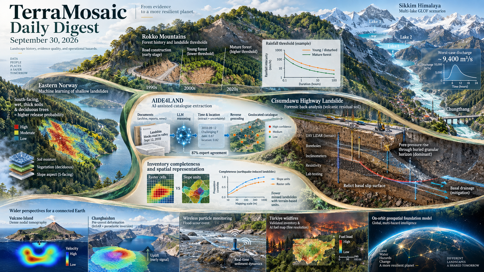
Landslide studies in the September 30 issue connect long-term environmental change with operational hazard thresholds. In Japan's Rokko Mountains, four event inventories and century-scale land-cover and rainfall records show that young forest and road construction lowered initiation thresholds, while forest maturation raised them and reduced small failures. An eastern Norway study reaches a complementary result from spatial machine learning: after accounting for clustering, shallow release is best explained by soil and vegetation state, with thick, wet, south-facing soils and deciduous stands carrying the strongest signal. Together, the papers argue that warning thresholds and susceptibility factors are conditional on landscape history rather than fixed site attributes.
Catalogue and inventory quality becomes a scientific result in its own right. AIDE4LAND formalizes expert rules for extracting landslide time and location from text, combines LLM prompting with reverse-geocoding, and reaches maximum agreement with experts in 87% of 2,162 tests. A separate earthquake-landslide study quantifies the minimum interpretation scale needed for an acceptably complete inventory, while a mapping-unit comparison tests how slope units and raster cells reshape susceptibility assessment. These contributions address three distinct error sources: missing events, uncertain event metadata and spatial representation.
Process studies preserve evidence across initiation, movement and consequence. Multi-lake GLOF simulations in Sikkim examine seven breach combinations and produce a worst-case discharge near 9,400 m³/s at Chungthang. For the reactivated Cisumdawu highway landslide, UAV LiDAR, boreholes, inclinometers, resistivity and laboratory testing constrain a relict basal surface before probabilistic calibration; pore-pressure rise through a granular horizon, rather than embankment strength, dominates the diagnosis. Title-level Engineering Geology records extend the frontier to monitoring-derived precipitation thresholds, lithology-aware InSAR and high-resolution 3D Material Point Method runout simulation, with their unobserved results left unstated.
The wider collection links hazard observation to constrained AI and reusable evidence. Dense nodal tomography images volatile pathways beneath Vulcano, Sentinel-1 and poroelastic inversion resolve pre-unrest hydrothermal deformation at Changbaishan, and wireless particles demonstrate flood-scour monitoring in a natural event. A validated Türkiye wildfire inventory preserves provenance while weak supervision converts coarse fuel labels into 10 m mapping; a title-level Journal of Hydrology record flags the superposition of urban waterlogging and levee-breach flooding. GRDisaster, GeoFWI3D, RainAtlas and an on-orbit geospatial foundation model extend the same emphasis on interpretable, transferable and operational evidence.
Key Trends
The strongest work treats changing landscape state, evidence quality and operational constraints as parts of the hazard model itself.
- Thresholds depend on landscape history: Rokko records connect initiation and size distributions to forest succession, roads and legacy sediment, while Norway models show that soil wetness, thickness and tree type remain important after spatial clustering is handled.
- Inventory construction is moving into the uncertainty budget: AIDE4LAND standardizes time and location extraction, the earthquake-landslide study quantifies interpretation scale, and mapping-unit analysis tests how the spatial support of labels changes susceptibility results.
- Forensic evidence constrains models before calibration: The Cisumdawu analysis fixes its basal surface from independent field observations, and the Sikkim scenarios keep individual and simultaneous lake failures visible instead of collapsing them into one design event.
- Multimodal systems are being judged by operational evidence: Disaster VLMs align cross-view imagery, Taiwan disruption mapping geocodes bilingual reports, and port analysis uses AIS and satellite observations to check text-led synthesis.
- Reusable data products retain provenance and transfer tests: GeoFWI3D and RainAtlas provide cross-task or cross-region benchmarks, Türkiye's wildfire inventory records how locations were repaired, and fuel mapping tests whether coarse supervision can support fine-resolution products; physics-informed pretraining and InSAR decomposition expose where apparent generalization can fail.
Selected Papers
The September 30 selection is led by centennial landslide-threshold analysis, AI-assisted catalogue construction, spatially explicit shallow-release modelling, earthquake-landslide inventory completeness, multi-lake GLOF scenarios and a forensic reactivation diagnosis. Companion studies cover mapping-unit effects, InSAR, 3D runout simulation, compound flooding, extreme precipitation, wildfire inventories and fuel mapping, volcano unrest, seismic imaging, precipitation forecasting and on-orbit geospatial AI.
1. Initiation thresholds and statistical properties of rainfall-induced landslides under centennial-scale variations in land use and land cover and rainfall characteristics
Core Problem: Rainfall thresholds are commonly treated as stationary even though forest age, roads, earlier sediment production and rainfall regimes change over decades.
Key Innovation: Four Rokko Mountain event inventories are interpreted with century-scale land-cover and rainfall records: young forest and road construction lowered initiation thresholds, forest maturation raised them and reduced small failures, and legacy sediment altered the size-frequency distribution.
2. Unravelling GLOF Hazards in the Sikkim Himalaya: Simulating Multi-Lake Flood Scenarios Under Extreme Conditions
Core Problem: Single-lake breach studies can miss correlated or cascading failures among Himalayan lakes exposed to the same climatic, seismic or mass-movement triggers.
Key Innovation: Seven HEC-RAS scenarios combine breaches at South Lhonak, Gurudongmar and Shako Cho; the three-lake case reaches about 9,400 m³/s at Chungthang, with modelled depths of 5–20 m and velocities of 1–4 m/s.
3. Spatial machine learning modelling reveals that soil indicators and tree type best explain shallow landslide release
Core Problem: Clustered landslide inventories can overstate predictor importance when spatial dependence is ignored.
Key Innovation: Spatially aware machine-learning models of an eastern Norway rainfall event identify thick, wet, south-facing soils as leading controls and show higher release likelihood under deciduous forest than spruce or pine.
4. The Minimum Interpretation Scale of an Earthquake-Induced Landslide Inventory with Acceptable Completeness
Core Problem: Landslide inventories change with interpretation scale, yet mapping programs lack a defensible minimum scale for acceptable completeness.
Key Innovation: The study quantifies scale-dependent inventory completeness and proposes a minimum interpretation scale, turning a usually implicit cartographic choice into a measurable quality-control decision.
5. AI-based procedure for extracting spatial and temporal information on rainfall-induced landslides from textual sources
Core Problem: Manual reconstruction of landslide time and location from heterogeneous text is slow, subjective and difficult to reproduce.
Key Innovation: AIDE4LAND combines explicit temporal rules, LLM prompting, reverse-geocoding and OpenStreetMap validation; 2,162 tests on 725 sources achieved maximum spatial-temporal concordance with experts in 87% of cases.
6. Forensic back-analysis of a reactivated deep-seated landslide in volcanic residual soils of the Cisumdawu highway KM 178, Indonesia
Core Problem: The 2021 Cisumdawu highway failure had been treated as an embankment problem although field evidence suggested a deeper relict landslide complex.
Key Innovation: Six independent evidence streams constrain the failure surface before probabilistic calibration; results identify lateral recharge to a buried granular horizon and pore-pressure rise, rather than embankment strength, as the dominant control and favor basal drainage for mitigation.
7. Thermokarst Lake Extraction and Dynamics With scSE-U-Net and Polarimetric Sentinel-1 Images: A Case Study in the Yellow River Source Region
Core Problem: Small thermokarst lakes are difficult to separate from complex alpine backgrounds, limiting consistent observation of permafrost-driven hydrologic change.
Key Innovation: An scSE-U-Net fuses VV, VH and PCA features from Sentinel-1 and reports high lake-mapping scores; the 2014–2023 analysis links changing lake counts chiefly to thermokarst lakes and associates area variations with precipitation and temperature.
8. Shallow Poroelastic Hydrothermal Deformation at Changbaishan Volcano Before the 2020 Unrest Revealed by Sentinel-1 InSAR Time Series
Core Problem: Slow deformation at dormant volcanoes can be difficult to distinguish between magmatic and hydrothermal sources.
Key Innovation: Sentinel-1 time series detect up to 3.5 mm/yr subsidence before Changbaishan's 2020 unrest; CO₂-constrained poroelastic modelling places the source about 2.7 km deep in a shallow hydrothermal system.
9. Volatile Conduits Beneath Vulcano Island (Italy) Revealed by High-Resolution Nodal Local Earthquake Tomography During Volcanic Unrest
Core Problem: Forecast interpretation at Vulcano is limited by incomplete knowledge of shallow fluid and gas pathways.
Key Innovation: A dense one-month nodal network detected 1,749 local earthquakes and resolved 3D velocity-ratio anomalies consistent with fluid-rich conduits and gas- or vapor-dominated reservoirs in the upper plumbing system.
10. Decoding the Disaster: Multi-Task Geospatial Reasoning with Vision-Language Models and Crowdsourced Imagery for Disaster Mapping
Core Problem: Crowdsourced disaster images are timely but lack reliable location and structured damage evidence.
Key Innovation: GRDisaster supplies 26,340 human-validated VGI, street-view and satellite-image triplets and combines cross-view geolocation with interpretable damage indicators for multi-task VLM evaluation.
11. GeoFWI3D: Large-scale 3D Velocity Model Dataset for Deep Learning-assisted Seismic Imaging
Core Problem: Deep-learning-assisted 3D full-waveform inversion lacks large, realistic and consistently labelled training data.
Key Innovation: GeoFWI3D releases 10,000 geological velocity volumes with reflectivity, relative geologic time, fault and salt labels, plus baselines for inversion, segmentation, neural operators and generative modelling under CC BY 4.0.
12. Machine learning surrogates for flash flood hazard mapping: CSI-optimized feature selection and spatial transferability
Core Problem: Fast flood-hazard surrogates can lose skill when transferred beyond the basins used for model development.
Key Innovation: The study combines critical-success-index-optimized feature selection with explicit spatial-transfer evaluation, aligning surrogate design with the operational requirement to generalize across catchments.
13. Effects of mapping units on landslide susceptibility assessment: a comparative analysis of slope units and raster cells
Core Problem: Raster cells and slope units encode terrain differently and can change both predictions and interpretation of controlling factors.
Key Innovation: A controlled comparison evaluates the consequences of the two mapping units for landslide susceptibility, separating a foundational spatial-design choice from the classifier itself.
14. Structured Chain-of-Thought with Self-Correction for Training-Free Damage Grading of Pre-Localized Buildings Using Qwen3-VL-30B
Core Problem: Vision-language damage assessment can produce plausible but inconsistent grades when reasoning is not tied to a structured evidence check.
Key Innovation: A Qwen3-VL-30B workflow uses structured chain-of-thought and self-correction to grade pre-localized buildings without task-specific training, offering a transferable pattern for auditable rapid mapping.
15. On-Orbit Execution of a Geospatial Foundation Model
Core Problem: Large geospatial models are usually evaluated on the ground, leaving latency, power and memory constraints of orbital deployment unresolved.
Key Innovation: The paper demonstrates execution of a geospatial foundation model on orbital hardware and reports a concrete route toward processing observations before downlink.
16. Monitoring flood-induced scour hazards using wireless tracking particles: from laboratory development to field demonstration
Core Problem: Bridge scour is difficult to observe during floods because direct inspection is dangerous and fixed measurements can miss sediment mobilization.
Key Innovation: Instrumented particles remain dormant in stable bed material and transmit after movement; laboratory tests and a natural-flood field deployment establish feasibility while the authors explicitly note the limited field sample.
17. Data-driven precipitation thresholds for landslides acceleration based on long-term in-situ monitoring (Italian Alps and Apennines)
Core Problem: Long-term in-situ displacement records could support acceleration thresholds tailored to slow-moving landslides in different Italian settings.
Key Innovation: The verified title and author record identify a data-driven threshold study spanning the Alps and Apennines; methods, sample size and performance cannot be assessed because a reliable abstract was unavailable.
18. Lithological control on landslide detection and dynamics revealed by two-pass InSAR in the Northern Apennines of Italy
Core Problem: Lithology can influence both real slope motion and how reliably InSAR detects that motion.
Key Innovation: The verified title identifies a two-pass InSAR analysis of lithological controls in the Northern Apennines; processing details and quantitative results cannot be assessed because a reliable abstract was unavailable.
19. Advancing the predictive capability of landslide simulations using the high-resolution three-dimensional Material Point Method
Core Problem: Three-dimensional landslide forecasts remain constrained by computational cost, uncertain failure surfaces and poorly calibrated mobility parameters.
Key Innovation: The verified article record and conference metadata establish a high-resolution 3D Material Point Method workflow for failure and runout prediction; journal-level quantitative validation was unavailable in the retrieved abstract.
20. Network-wide mapping of multi-hazard transport disruptions across Taiwan using news media reports
Core Problem: Formal disaster databases often omit localized transport disruption across steep, hazard-prone networks.
Key Innovation: A bilingual search dictionary, LLM filtering and OpenStreetMap linkage turn news reports into a geocoded Taiwan disruption inventory, demonstrated on eastern-coast impacts during Typhoon Gaemi.
21. Three-Dimensional Simulation of Flood Propagation at Syabrubesi, Nepal
Core Problem: Confined channel bends and junction geometry can control destructive local velocities during Himalayan flood propagation.
Key Innovation: A free-surface Navier–Stokes model on pre-event terrain simulates the August 2026 Syabrubesi flood path and identifies strongly accelerated flow through confined reaches; the calculation remains scenario-based rather than a calibrated reconstruction.
22. In the Age of AI-Are National Models and Data Sets Still Important for Stream Flow Prediction?
Core Problem: Accurate streamflow prediction is critical for effective water resource management, and recent advances in deep learning and multi-basin data sets have significantly improved model skill.
Key Innovation: However, these models rely solely on globally available meteorological inputs, potentially overlooking the value of nationally developed data sets with enhanced regional accuracy. For countries with dense observational networks and distinct hydrological regimes, investing in national data sets and models can enhance deep-learning model prediction accuracy, leading to improved resilience to climate extremes and local water management decisions.
23. Unsupervised Domain Adaptation for Enhanced Radiometer Image Precipitation Estimation using Conditional Flow Matching
Core Problem: Deep generative networks have recently achieved unprecedented performance in precise image and video editing using sophisticated textual prompts.
Key Innovation: In this paper, we investigate the potential of flow matching models for unsupervised domain adaptation of satellite radiometer images. Extensive experiments conducted on the GPM-Core constellation show the benefit of our conditional domain adaptation, particularly in improving rain precipitation estimation from radiometer imagery.
24. Comparing a gradient boosting algorithm to the GOES FDC for wildfire detection
Core Problem: Wildfires pose severe risks to human life, ecosystems, and property.
Key Innovation: This study presents a machine learning approach for wildfire detection from GOES ABI imagery. This study demonstrates that machine learning models may offer significant improvements over existing geostationary fire products, including higher accuracy, fewer false alarms, and earlier detection.
25. Varda-single-1.0: deterministic data-driven weather forecasting at 1 km resolution over Switzerland's complex topography
Core Problem: We present Varda-single-1.0, a medium-range data-driven weather prediction system built for the Alpine domain.
Key Innovation: The system comprises two independently trained stretched-grid Graph Transformer models with encoder-processor-decoder architecture, developed in the Anemoi framework: a 6-hourly autoregressive forecaster and a temporal downscaler reconstructing hourly forecasts between the forecaster's steps. To gain insight into the model's behaviour, we investigate three case studies beyond the aggregated headline scores, and find particular weaknesses in Varda-single's representation of local winds over complex terrain.
26. Weakly Supervised Fine-Resolution Wildfire Fuel Mapping From Spatially Coarse Labels and Multisource Remote Sensing Data
Core Problem: Fine-resolution wildfire fuel labels are expensive and scarce, limiting large-area mapping in heterogeneous northern landscapes.
Key Innovation: L2HFuelNet fuses Sentinel-1, Sentinel-2 and topography to learn 10 m fuel classes from spatially inexact 30 m labels; province-wide Alberta evaluation reports 0.91 overall accuracy and 0.84 mean intersection-over-union, with an open map and implementation.
27. Anthropogenic aerosol forcing of European windstorms in CMIP6 climate models
Core Problem: A recently developed set of historical storm reconstructions were extensively validated by insurance loss data and revealed how European windstorm damages were three times higher in the 1980s and '90s compared to a few decades before and since.
Key Innovation: While this evidence suggests AA forcing contributed significantly to recent multidecadal changes in European windstorm losses, there remains significant uncertainties in model responses and the observational data used in their validation. A validation of these modelling results using independent data from previous climate studies suggested the signal is more likely to be at the higher end of this range.
28. Weather station data from the Mount Everest region, Nepal: 3810-8810 m above sea level
Core Problem: Weather station data from the Mount Everest region, Nepal: 3810-8810 m above sea level Arbindra Khadka, Lester Baker Perry, Tom Matthews, Tenzing Gyalzen Sherpa, Chitra Bahadur Shrestha, Dibas Shrestha, Deepak Aryal, Subash Tuladhar, Niraj Pradhananga, Dinkar Kayastha, Brian Raichle, Peter Athans, Dawa Yangzum Sherpa, Keith Garrett, Garrett Wheeler, Tom Young, and Aurora Elmore Earth Syst.
Key Innovation: Our results show differences between observations and widely used ERA5 datasets. This improved knowledge helps scientists better understand mountain weather and climate, climate change and supports water resource planning for communities downstream.
29. A Geographically Validated Administrative Wildfire Inventory for Türkiye (2013-2025)
Core Problem: Administrative fire archives lose scientific value when place names, coordinates and district assignments conflict.
Key Innovation: A five-stage workflow harmonizes text, checks official boundaries, uses VIIRS detections for coordinate recovery and retains provenance flags for every record in Türkiye's 2013–2025 inventory instead of silently discarding problematic events.
30. Port-Agent: Structured Multimodal Reasoning for Port Disruption Analysis Using AIS, Satellite Imagery, and News
Core Problem: Textual accounts establish essential context for port disruptions but can bias large language model synthesis before independent observations are examined.
Key Innovation: We present Port Agent, a remote-sensing agent that aligns Automatic Identification System (AIS) trajectories, Sentinel-2 vessel detections, and documents while retaining acquisition time, footprint, processing, and uncertainty. Although the system comparison remains exploratory, the results support an auditable evidence chain in which AIS and satellite observations constrain text-led synthesis.
31. Multi-Lead Forecasting of Precipitable Water Vapor over Xinjiang Using Fengyun-4B Satellite and GNSS Observations
Core Problem: Atmospheric water vapor is a key driver of weather variability, and accurate forecasts of precipitable water vapor (PWV) can support quantitative precipitation forecasting.
Key Innovation: This study develops a regional multi-lead PWV forecasting framework for Xinjiang, China, by combining Fengyun-4B (FY-4B) Advanced Geosynchronous Radiation Imager (AGRI) observations with ground-based GNSS PWV measurements. The results demonstrate that satellite-driven machine learning can provide useful very-short-range PWV guidance, particularly within the first 12 h.
32. Monitoring the Transformation of an Aging Plain Reservoir: InSAR-Derived Deformation Associated with Dredging and Capacity Expansion at Suyahu Reservoir, China
Core Problem: Reservoir sedimentation reduces operational performance, while large-scale dredging and capacity expansion redistribute earth materials and alter engineering conditions at aging plain reservoirs.
Key Innovation: This study integrates Sentinel-1 time-series Interferometric Synthetic Aperture Radar (InSAR), multitemporal optical imagery, and ICESat-2 and Sentinel-3A altimetry to characterize the engineering transformation and associated deformation at Suyahu Reservoir, China. InSAR revealed spatially heterogeneous negative line-of-sight velocities reaching approximately −40 mm/a along localized embankment sections and −50 mm/a along the monitored margins of the artificial islands.
33. On the Limitations of InSAR Decomposition Imposed by Displacement Direction and Coordinate System
Core Problem: Satellite-based Interferometric Synthetic Aperture Radar (InSAR) is widely used to monitor ground deformation over large areas.
Key Innovation: Consequently, two independent ascending and descending line-of-sight observations can determine only two independent displacement components unless an additional physical constraint or external observation is introduced. The results show that a constraint aligned with the null direction prevents the unobservable displacement component from biasing the two estimated components, whereas even small coordinate-system misalignments with respect to the true displacement direction may produce substantial errors when the constrained direction is poorly oriented with respect to the null direction.
34. Frequency-Aware Hierarchical Feature Fusion Network for Tornado Detection Using Dual-Polarization Weather Radar
Core Problem: Tornadoes are extremely hazardous weather phenomena characterized by intense vortex structures, and weather radar is currently one of the most effective means for detecting them.
Key Innovation: Therefore, a Frequency-Aware Hierarchical Feature Fusion Network (FA-HFFN) is proposed based on dual-polarization weather radar observations. Experimental results show that FA-HFFN outperforms the comparison models in overall evaluation metrics, with higher detection sensitivity and stronger false-alarm suppression.
35. Physical Properties in the Northern Ecuador Subduction Zone Appear to Contribute to the Occurrence of Moderate-to-Strong Earthquakes and Aftershock Propagation
Core Problem: Megathrust faults in subduction zones often serve as seismogenic environments for destructive earthquakes.
Key Innovation: To verify whether the material properties of subduction zones influence aftershock propagation and earthquake magnitude, we investigated the northern Ecuador subduction zone using local 8G network data to locate seismicity in July 2016 and obtained the deformation field (the maximum deformation reached about 60 cm) of the 2016 Mw 7.8 earthquake from InSAR. Both the aftershock and the relocated historical events are found to be concentrated in regions with moderate Vp/Vs ratios (~1.78-1.82), indicating that the material properties in these areas may facilitate subduction zone aftershock propagation and the nucleation of moderate-to-large earthquakes.
36. Establishment of a High Spatiotemporal Resolution Data Production Methodology Through Combined Observation of Geostationary and Polar-Orbiting Satellites
Core Problem: Conventional satellite observation faces a trade-off between temporal frequency and spatial resolution.
Key Innovation: This study establishes a methodology that combines the high-frequency observations of the geostationary Himawari-8 Advanced Himawari Imager (AHI; 10 min intervals, 0.5-1 km) with the polar-orbiting GCOM-C Second-generation Global Imager (SGLI; 250 m) to produce a daily, 250 m surface reflectance product for Japan in 2019. These results demonstrate that observation-based sensor fusion can mitigate the spatiotemporal trade-off, with applications in climate change monitoring, disaster response, and forest management.
37. Multiscale diagnosis of extreme precipitation over complex terrain in the western part of northern Xinjiang by integrating weather typing and dynamical downscaling
Core Problem: Regional circulation classes alone do not resolve how terrain and convection produce extreme precipitation in western northern Xinjiang.
Key Innovation: The study combines objective weather typing with convection-permitting dynamical downscaling to connect synoptic patterns with event-scale terrain–convection mechanisms.
38. Mapping multi-hazard flood and drought risk in a rapidly growing region: A ward-level assessment in the Bengaluru Metropolitan Region, India
Core Problem: Title-level focus: Mapping multi-hazard flood and drought risk in a rapidly growing region: A ward-level assessment in the Bengaluru Metropolitan Region, India.
Key Innovation: The verified bibliographic record identifies the study focus, but methods, data and results cannot be assessed because a reliable abstract was unavailable.
39. Data-driven reconstruction of incomplete earthquake catalogs: Validation and application to the Yutian region, Xinjiang, China
Core Problem: Title-level focus: Data-driven reconstruction of incomplete earthquake catalogs: Validation and application to the Yutian region, Xinjiang, China.
Key Innovation: The verified bibliographic record identifies the study focus, but methods, data and results cannot be assessed because a reliable abstract was unavailable.
40. Spatiotemporal evolution and driving mechanisms of superposition effects of rainfall-induced urban waterlogging and levee breach flooding
Core Problem: Rainfall-driven waterlogging and levee-breach inundation can overlap in space and time, yet their superposition is often assessed separately.
Key Innovation: The verified title, authors, PII and Crossref DOI establish a study of spatiotemporal evolution and driving mechanisms of the combined hazard; methods and results cannot be assessed because a reliable abstract was unavailable.
41. A Data-Free Physics-Informed Neural Operator for Level-Set Interface Advection
Core Problem: Operators for interfacial problems are trained on reference solutions produced by the solver they are intended to replace.
Key Innovation: This work develops a data-free physics-informed neural operator for level-set interface advection, in which the interface is the equation's unknown and the operator maps an initial interface to the full spatiotemporal trajectory under a prescribed flow. Where the constraint is valid the physics-trained operator conserves enclosed area 2.7 times better than the supervised baseline despite a larger field error, and a hybrid arm using eight reference solutions outperforms a supervised arm using sixteen.
42. Aperture: Training-Free Multiscale Concept Bottlenecks for Remote Sensing
Core Problem: While earth observation models have advanced substantially, they still lack interpretability.
Key Innovation: In image space, we propose a multiscale concept bottleneck using greedy quadtree routing to locate small concepts. Targeted component-removal tests examine whether concept scores respond to changes in visual evidence, while temporal experiments show that descriptor updates improve recognition of technological changes without retraining.
43. Proper Scoring Rule-based Diffusion for Probabilistic Weather Forecasting
Core Problem: Recent probabilistic weather forecasters train stochastic predictors with the continuous ranked probability score (CRPS) to generate each ensemble member in a single forward pass.
Key Innovation: To learn the predictive distribution more effectively, we introduce auxiliary conditional denoising tasks that predict the same future state from the context and its corrupted version, which provides partial future information that can reduce prediction ambiguity. The gains extend to high-dimensional global weather forecasting under both training from scratch and fine-tuning, along with improved calibration and potential benefits for generalization under distribution shift.
44. RainAtlas: A Multi-Continental Dataset for Precipitation Downscaling
Core Problem: Extreme rainfall events are increasing in intensity and frequency as climate change accelerates.
Key Innovation: Machine learning models are widely used to downscale precipitation data to km-scale, but their application to unseen geographies presents challenges. Our evaluation reveals substantial variance in out-of-domain generalization depending on the training regions.
45. PrecipJEPA: JEPA-Regularized Future-State Prediction with Motion-Source Rendering for Precipitation Nowcasting
Core Problem: Long-term precipitation nowcasting requires modeling radar-echo evolution while preserving localized high-intensity structures.
Key Innovation: We propose PrecipJEPA, which couples a structured forecasting path with an auxiliary path that enriches its encoder from observed radar history. Experiments on SEVIR and MeteoNet show that PrecipJEPA improves highest-threshold CSI by 118.6% and 35.1%, respectively, over the strongest baselines, while maintaining the highest mean CSI throughout the 3-hour forecast.
46. Residuals Are Not Enough: Limits of Physics-Informed Pre-Training for Scientific Foundation Models
Core Problem: Scientific foundation models (SciFMs) aim to learn generalizable representations of physical systems governed by partial differential equations (PDEs), enabling transfer across tasks and domains.
Key Innovation: In this evaluation study, we investigate whether (and how) physics-informed pre-training improves the generalization, robustness, and data efficiency of SciFMs. Our results show that physics-informed pre-training provides clear benefits in ``nice,'' e.g., structured, well-aligned settings: it enhances generalization and reduces data dependence, compared to data-only pre-training.
47. Shear-Thinning Rheology Reshapes Hydrodynamic Dispersion in Heterogeneous Fractures
Core Problem: Hydrodynamic dispersion of shear-thinning fluid in fractured rocks is jointly governed by fracture heterogeneity and fluid rheology, yet the way aperture correlation length alters dispersion mechanisms remains unclear.
Key Innovation: Here, we carry out pore-scale lattice Boltzmann simulations to investigate fluid flow and solute transport in heterogeneous fractures with systematically varied aperture correlation lengths and injection velocities. These findings provide a pore-scale mechanistic explanation for the transition and reorganization of dispersion regimes in heterogeneous fractures.
48. Beyond Pointwise Error: A Multi-Metric Evaluation of Spatial Climate Downscaling
Core Problem: Climate downscaling aims to reconstruct fine scale spatial fields from coarse resolution inputs.
Key Innovation: This work presents a multi metric benchmark comparing five spatial downscaling methods on ERA5 temperature, wind, and precipitation fields. These results show that there is no single best downscaling method.
49. Fabric evolution of carbonate and silica sand under simple shear using synchrotron X-ray microtomography
Core Problem: Fabric anisotropy governs the mechanical behaviour of granular soils, yet direct microstructural observations during Direct Simple Shear (DSS) remain scarce, particularly for carbonate sands.
Key Innovation: For this purpose, a radiolucent shear device was developed to enable scanning of full-scale specimens without miniaturisation or resin fixation, mitigating boundary artefacts. Image-derived particle-size distributions showed no systematic shift towards finer sizes, indicating no evidence of appreciable particle breakage at 25 kPa.
50. Impact of Compliance on Constant-Height Simple Shear Tests
Core Problem: Simple shear testing is an important laboratory tool in geotechnical engineering, providing insights into soil behavior under conditions relevant to landslides, foundation instability, and earthquake loading.
Key Innovation: This study quantifies compliance in simple shear equipment and evaluates its impact on monotonic and cyclic tests. These observations highlight the need to improve compliance control in commercially available simple shear equipment and to improve how constant-height control is evaluated and reported.
51. Snowball refrigeration of Earth’s crust mimics glacial erosion
Core Problem: Glaciation cools the crust by setting its surface temperature to 0°C or well below.
Key Innovation: During the Cryogenian Snowball Earth glaciations, these conditions were in place long enough to cool the entire crustal column. Rock cooling previously attributed to massive Snowball erosion and linked to the Great Unconformity may instead reflect a great refrigeration of Earth’s crust, with implications for thermochronology across other climate events.